Canvas Print > Animals > Birds > Gruiformes > Rallidae > Red Rail
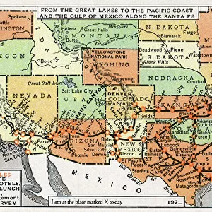
Canvas Print : Map, route of Santa Fe Railroad, USA


![]()
Canvas Prints from Mary Evans Picture Library
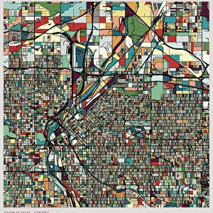
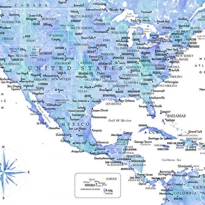
Map, route of Santa Fe Railroad, USA
Map showing the route of the Santa Fe Railroad, USA, from the Great Lakes in the east, to the Gulf of Mexico in the south, and the Pacific coast in the west. Red circles indicate Santa Fe hotels, dining and lunch rooms, under the management of the Fred Harvey Company (Harvey House). Date: 1921
Mary Evans Picture Library makes available wonderful images created for people to enjoy over the centuries
Media ID 14233572
© Mary Evans / Pharcide
1921 Angeles Canyon Chicago Circles Continent Denver Dining Francisco Fred Galveston Gulf Harvey Hotels Kansas Lakes Lunch Management Maps Mexico Pacific Railroad Rooms Route
30"x20" (76x51cm) Canvas Print
"Step back in time with our stunning Santa Fe Railroad Canvas Print from Media Storehouse. This captivating map depicts the historic route of the iconic railroad, spanning from the Great Lakes in the east to the Pacific coast in the west, and all the way to the Gulf of Mexico in the south. Meticulously sourced from Mary Evans Prints Online, this rights managed image is sure to be a conversation starter in any room. Bring the rich history of American railroads into your home or office with this beautiful, high-quality canvas print."
Delivered stretched and ready to hang our premium quality canvas prints are made from a polyester/cotton blend canvas and stretched over a 1.25" (32mm) kiln dried knot free wood stretcher bar. Packaged in a plastic bag and secured to a cardboard insert for safe transit.
Canvas Prints add colour, depth and texture to any space. Professionally Stretched Canvas over a hidden Wooden Box Frame and Ready to Hang
Estimated Product Size is 76.2cm x 50.8cm (30" x 20")
These are individually made so all sizes are approximate
Artwork printed orientated as per the preview above, with landscape (horizontal) orientation to match the source image.
FEATURES IN THESE COLLECTIONS
> Animals
> Birds
> Gruiformes
> Rallidae
> Red Rail
> Animals
> Mammals
> Muridae
> House Mouse
> Maps and Charts
> Early Maps
> Maps and Charts
> Related Images
> North America
> Mexico
> Lakes
> Related Images
> North America
> Mexico
> Maps
> North America
> Mexico
> Mexico City
> North America
> Mexico
> Related Images
EDITORS COMMENTS
This map print from 1921 showcases the extensive route of the Santa Fe Railroad in the United States, connecting the Great Lakes in the east to the Gulf of Mexico in the south, and the Pacific coast in the west. The intricate network of rail lines stretches across various American states, including Kansas, Colorado, New Mexico, Arizona, and California. Red circles scattered throughout the map highlight notable establishments under the management of the renowned Fred Harvey Company - Harvey Houses. These establishments offered travelers a respite from their journeys, providing dining and lunch rooms where they could enjoy a hearty meal and rest. Some of these iconic Harvey Houses include those in Chicago, Galveston, Denver, Grand Canyon, Los Angeles, and San Francisco. The Santa Fe Railroad, established in 1859, was a significant player in the transportation industry during the 1920s, making long-distance travel across the continent more accessible and convenient for Americans. This map serves as a fascinating glimpse into the rich history of rail travel during this era, offering a visual representation of the vast network that connected the country from one coast to another.
MADE IN AUSTRALIA
Safe Shipping with 30 Day Money Back Guarantee
FREE PERSONALISATION*
We are proud to offer a range of customisation features including Personalised Captions, Color Filters and Picture Zoom Tools
SECURE PAYMENTS
We happily accept a wide range of payment options so you can pay for the things you need in the way that is most convenient for you
* Options may vary by product and licensing agreement. Zoomed Pictures can be adjusted in the Cart.