Cushion > Animals > Birds > Gruiformes > Rallidae > Red Rail
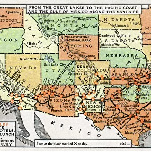
Cushion : Map, route of Santa Fe Railroad, USA


![]()
Home Decor from Mary Evans Picture Library
Map, route of Santa Fe Railroad, USA
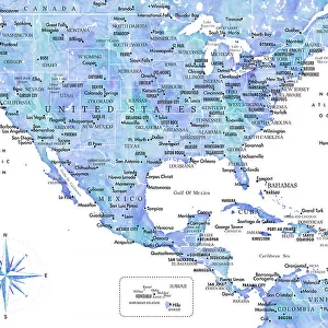
Map showing the route of the Santa Fe Railroad, USA, from the Great Lakes in the east, to the Gulf of Mexico in the south, and the Pacific coast in the west. Red circles indicate Santa Fe hotels, dining and lunch rooms, under the management of the Fred Harvey Company (Harvey House). Date: 1921
Mary Evans Picture Library makes available wonderful images created for people to enjoy over the centuries
Media ID 14233572
© Mary Evans / Pharcide
1921 Angeles Canyon Chicago Circles Continent Denver Dining Francisco Fred Galveston Gulf Harvey Hotels Kansas Lakes Lunch Management Maps Mexico Pacific Railroad Rooms Route
Cushion
Refresh your home decor with a beautiful full photo 16"x16" (40x40cm) cushion, complete with cushion pad insert. Printed on both sides and made from 100% polyester with a zipper on the bottom back edge of the cushion cover. Care Instructions: Warm machine wash, do not bleach, do not tumble dry. Warm iron inside out. Do not dry clean.
Accessorise your space with decorative, soft cushions
Estimated Product Size is 40cm x 40cm (15.7" x 15.7")
These are individually made so all sizes are approximate
Artwork printed orientated as per the preview above, with landscape (horizontal) or portrait (vertical) orientation to match the source image.
FEATURES IN THESE COLLECTIONS
> Animals
> Birds
> Gruiformes
> Rallidae
> Red Rail
> Animals
> Mammals
> Muridae
> House Mouse
> Maps and Charts
> Early Maps
> Maps and Charts
> Related Images
> North America
> Mexico
> Lakes
> Related Images
> North America
> Mexico
> Maps
> North America
> Mexico
> Mexico City
> North America
> Mexico
> Related Images
EDITORS COMMENTS
This map print from 1921 showcases the extensive route of the Santa Fe Railroad in the United States, connecting the Great Lakes in the east to the Gulf of Mexico in the south, and the Pacific coast in the west. The intricate network of rail lines stretches across various American states, including Kansas, Colorado, New Mexico, Arizona, and California. Red circles scattered throughout the map highlight notable establishments under the management of the renowned Fred Harvey Company - Harvey Houses. These establishments offered travelers a respite from their journeys, providing dining and lunch rooms where they could enjoy a hearty meal and rest. Some of these iconic Harvey Houses include those in Chicago, Galveston, Denver, Grand Canyon, Los Angeles, and San Francisco. The Santa Fe Railroad, established in 1859, was a significant player in the transportation industry during the 1920s, making long-distance travel across the continent more accessible and convenient for Americans. This map serves as a fascinating glimpse into the rich history of rail travel during this era, offering a visual representation of the vast network that connected the country from one coast to another.
MADE IN AUSTRALIA
Safe Shipping with 30 Day Money Back Guarantee
FREE PERSONALISATION*
We are proud to offer a range of customisation features including Personalised Captions, Color Filters and Picture Zoom Tools
SECURE PAYMENTS
We happily accept a wide range of payment options so you can pay for the things you need in the way that is most convenient for you
* Options may vary by product and licensing agreement. Zoomed Pictures can be adjusted in the Cart.