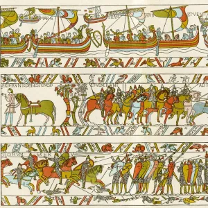
Canvas Print > North America > Cuba > Cuba Heritage Sites > Trinidad and the Valley de los Ingenios
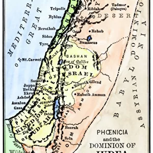
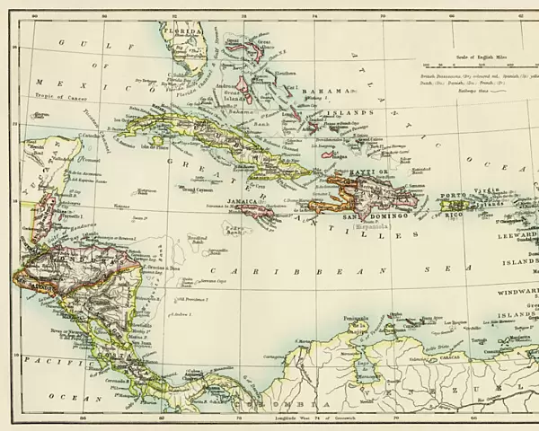
Canvas Print : Caribbean islands, 1870s


![]()
Canvas Prints from North Wind
Caribbean islands, 1870s
Map of West Indies and the Caribbean Sea, 1800s.
Printed color lithograph
North Wind Picture Archives brings history to life with stock images and hand-colored illustrations
Media ID 5881795
© North Wind Picture Archives
1870s America Caribbean Caribbean Sea Central America Chart Cuba Florida Gulf Of Mexico Haiti Hispaniola Jamaica Panama Santo Domingo West Indies Antilles Bahamas Caribbean Islands Costa Rica El Salvador Grenada Honduras Leeward Islands Nicaragua Puerto Rico Trinidad Virgin Islands Windward Islands
20"x16" (51x41cm) Canvas Print
Experience the vintage charm of yesteryears with our Media Storehouse Canvas Print featuring the enchanting image of "Caribbean Islands, 1870s" from the North Wind Picture Archives. This captivating 1800s map of the West Indies and the Caribbean Sea, printed in vibrant color lithograph, transports you back in time to an era of exploration and discovery. The intricate details of the map are beautifully rendered on premium canvas, creating a stunning visual masterpiece that adds a touch of history and character to any space. Bring the timeless beauty of the Caribbean to your home or office with our Media Storehouse Canvas Print.
Delivered stretched and ready to hang our premium quality canvas prints are made from a polyester/cotton blend canvas and stretched over a 1.25" (32mm) kiln dried knot free wood stretcher bar. Packaged in a plastic bag and secured to a cardboard insert for safe transit.
Canvas Prints add colour, depth and texture to any space. Professionally Stretched Canvas over a hidden Wooden Box Frame and Ready to Hang
Estimated Product Size is 50.8cm x 40.6cm (20" x 16")
These are individually made so all sizes are approximate
Artwork printed orientated as per the preview above, with landscape (horizontal) orientation to match the source image.
FEATURES IN THESE COLLECTIONS
> Maps and Charts
> Related Images
> Maps and Charts
> World
> North America
> The Bahamas
> Maps
> North America
> The Bahamas
> Related Images
> North America
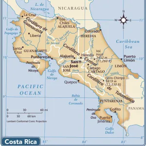
> Costa Rica
> Maps
> North America
> Costa Rica
> Related Images
> North America
> Cuba
> Cuba Heritage Sites
> Trinidad and the Valley de los Ingenios
> North America
> Cuba
> Maps
> North America
> Cuba
> Related Images
> North Wind Picture Archives
> Latin America:Caribbean
> North Wind Picture Archives
> Maps
EDITORS COMMENTS
This vintage print takes us back to the Caribbean islands in the 1870s, showcasing a beautifully detailed map of the West Indies and the Caribbean Sea from the 1800s. The printed color lithograph exudes an air of heritage and tradition, transporting us to a bygone era rich with history. The illustration depicts a vast expanse encompassing Florida, Panama, Nicaragua, Haiti, Cuba, Bahamas, Honduras, Grenada, Trinidad and many more enchanting locations. It serves as a visual time capsule capturing the diverse tapestry of these tropical lands during that period. As we explore this intricate chart-like map adorned with vibrant colors and precise details, it becomes evident how crucial these islands were for trade routes between America and Central America. From Costa Rica to Puerto Rico and even extending into the Gulf of Mexico; this region played a significant role in shaping world history. With its depiction of Windward Islands like Santo Domingo alongside Leeward Islands such as Virgin Islands; this artwork offers an immersive experience into discovering lesser-known places like El Salvador or Hispaniola. It reminds us of their importance within the New World narrative. This North Wind Picture Archives print is not just an art piece but also an educational tool providing insights into geography while igniting our curiosity about past civilizations that thrived on these shores. Let's cherish this remarkable glimpse into our shared cultural heritage!
MADE IN AUSTRALIA
Safe Shipping with 30 Day Money Back Guarantee
FREE PERSONALISATION*
We are proud to offer a range of customisation features including Personalised Captions, Color Filters and Picture Zoom Tools
SECURE PAYMENTS
We happily accept a wide range of payment options so you can pay for the things you need in the way that is most convenient for you
* Options may vary by product and licensing agreement. Zoomed Pictures can be adjusted in the Cart.