
Canvas Print > Universal Images Group (UIG) > Universal Images Group > Satellite and Aerial > Planet Observer 4
Canvas Print : State of Alabama, United States, Relief Map


![]()
Canvas Prints from Universal Images Group (UIG)
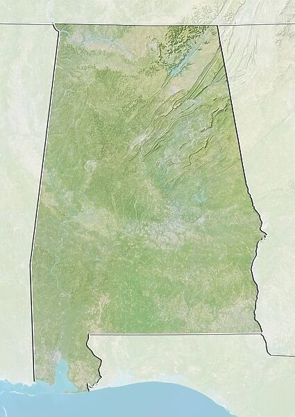
State of Alabama, United States, Relief Map
Relief map of the State of Alabama, United States. This image was compiled from data acquired by LANDSAT 5 & 7 satellites combined with elevation data
Universal Images Group (UIG) manages distribution for many leading specialist agencies worldwide
Media ID 9618751
© Planet Observer/UIG
Alabama Birmingham Coastline Gulf Of Mexico Montgomery Relief Map Shore State Satellite View
20"x16" (51x41cm) Canvas Print
Discover the beauty of Alabama in a whole new light with Media Storehouse's Canvas Prints. Featuring an intricately detailed relief map of the State of Alabama, this stunning design is derived from satellite data acquired by LANDSAT 5 & 7. The combination of topographical information and vivid colors brings the natural contours of the landscape to life. Add a touch of geographic artistry to your home or office décor with this unique and captivating representation of the United States' thirty-first state.
Delivered stretched and ready to hang our premium quality canvas prints are made from a polyester/cotton blend canvas and stretched over a 1.25" (32mm) kiln dried knot free wood stretcher bar. Packaged in a plastic bag and secured to a cardboard insert for safe transit.
Canvas Prints add colour, depth and texture to any space. Professionally Stretched Canvas over a hidden Wooden Box Frame and Ready to Hang
Estimated Product Size is 40.6cm x 50.8cm (16" x 20")
These are individually made so all sizes are approximate
Artwork printed orientated as per the preview above, with portrait (vertical) orientation to match the source image.
EDITORS COMMENTS
This print showcases the stunning relief map of the State of Alabama, United States. Created using data acquired by LANDSAT 5 & 7 satellites combined with elevation data, this image provides a detailed and accurate representation of Alabama's topography. The vibrant colors highlight the diverse landscapes found within the state, from its picturesque coastline along the Gulf of Mexico to its rolling hills and valleys further inland. The vertical perspective allows viewers to appreciate the intricate details of Alabama's physical geography. Montgomery, the capital city, and Birmingham, one of its largest urban centers, are clearly visible on this map. This photograph offers a unique satellite view that brings to life how these cities fit into their surrounding natural environment. With no people in sight, this image solely focuses on showcasing Alabama's natural beauty and geographical features. It serves as an excellent resource for cartographers or anyone interested in studying or exploring this southern state's terrain. Whether you're a resident or simply fascinated by North America's diverse landscapes, this print is sure to captivate your attention with its rich detail and striking visual appeal.
MADE IN AUSTRALIA
Safe Shipping with 30 Day Money Back Guarantee
FREE PERSONALISATION*
We are proud to offer a range of customisation features including Personalised Captions, Color Filters and Picture Zoom Tools
SECURE PAYMENTS
We happily accept a wide range of payment options so you can pay for the things you need in the way that is most convenient for you
* Options may vary by product and licensing agreement. Zoomed Pictures can be adjusted in the Cart.