Canvas Print > Universal Images Group (UIG) > Universal Images Group > Satellite and Aerial > Planet Observer 4
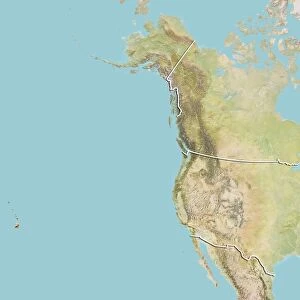
Canvas Print : United States and Canada, True Colour Satellite Image With Border


![]()
Canvas Prints from Universal Images Group (UIG)
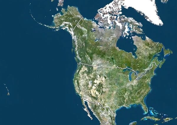
United States and Canada, True Colour Satellite Image With Border
Satellite view of the United States and Canada (with border). This image was compiled from data acquired by LANDSAT 5 & 7 satellites
Universal Images Group (UIG) manages distribution for many leading specialist agencies worldwide
Media ID 9613009
© Planet Observer/UIG
California Canada Canadian Rockies Chicago Coastline Colorado Florida Great Lakes Gulf Of Mexico Los Angeles Louisiana Mississippi Montreal Mountain Mountain Range New York City Ottawa Quebec Rocky Mountains San Francisco Shore Snow Texas Toronto Vancouver Saint Lawrence River Satellite View
20"x16" (51x41cm) Canvas Print
Discover a new perspective of North America with our Media Storehouse Canvas Print featuring a stunning True Colour Satellite Image of the United States and Canada, courtesy of Universal Images Group (UIG). Compiled from data acquired by LANDSAT 5 & 7 satellites, this captivating print showcases the vibrant hues and intricate details of the landscape, borders included. Bring the wonders of space into your home or office, and add an unique conversation starter to your decor. Order now and experience the beauty of our planet like never before.
Delivered stretched and ready to hang our premium quality canvas prints are made from a polyester/cotton blend canvas and stretched over a 1.25" (32mm) kiln dried knot free wood stretcher bar. Packaged in a plastic bag and secured to a cardboard insert for safe transit.
Canvas Prints add colour, depth and texture to any space. Professionally Stretched Canvas over a hidden Wooden Box Frame and Ready to Hang
Estimated Product Size is 50.8cm x 40.6cm (20" x 16")
These are individually made so all sizes are approximate
Artwork printed orientated as per the preview above, with landscape (horizontal) orientation to match the source image.
EDITORS COMMENTS
This stunning print captures the true colors of the United States and Canada, showcasing their vast landscapes and diverse topography. Taken from a satellite view with the border clearly visible, this image is a testament to the technological advancements in cartography. From coast to coast, this photograph showcases iconic locations such as Texas, Los Angeles, New York City, Toronto, Quebec, California, Florida, Chicago, Colorado, Vancouver and many more. The snow-capped mountains of the Rockies stand tall alongside the serene shores of Lake Michigan and the majestic Saint Lawrence River. The intricate details captured by LANDSAT 5 & 7 satellites allow us to appreciate North America's physical geography like never before. From the Great Lakes to the Gulf of Mexico and everything in between – this image presents an awe-inspiring display of nature's wonders. With no people present in this horizontal shot taken from space above our planet's surface; it reminds us just how small we are compared to these expansive landscapes that stretch out endlessly before us. Whether you're a lover of photography or simply fascinated by Earth's beauty from above - this print will transport you on a visual journey across two nations known for their natural splendor.
MADE IN AUSTRALIA
Safe Shipping with 30 Day Money Back Guarantee
FREE PERSONALISATION*
We are proud to offer a range of customisation features including Personalised Captions, Color Filters and Picture Zoom Tools
SECURE PAYMENTS
We happily accept a wide range of payment options so you can pay for the things you need in the way that is most convenient for you
* Options may vary by product and licensing agreement. Zoomed Pictures can be adjusted in the Cart.