Cushion > Historic > Ancient civilizations > Roman Empire > Roman art
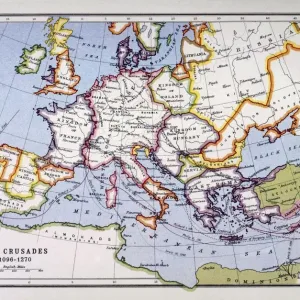
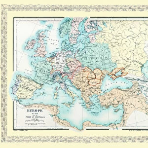
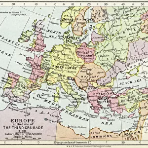
Cushion : Map of Europe at the time of the Third Crusade, 1190, from Historical Atlas


![]()
Home Decor from Fine Art Finder
Map of Europe at the time of the Third Crusade, 1190, from Historical Atlas
KW342818 Map of Europe at the time of the Third Crusade, 1190, from Historical Atlas, published by W. & A.K. Johnston Limited, 1911 (colour litho) by English School, (20th century); Private Collection; Ken Welsh; English, out of copyright
Media ID 12861733
© www.bridgemanimages.com
Byzantine Empire C12th Crusades Holy Roman Empire Holy War Historical Map
Cushion
Refresh your home decor with a beautiful full photo 16"x16" (40x40cm) cushion, complete with cushion pad insert. Printed on both sides and made from 100% polyester with a zipper on the bottom back edge of the cushion cover. Care Instructions: Warm machine wash, do not bleach, do not tumble dry. Warm iron inside out. Do not dry clean.
Accessorise your space with decorative, soft cushions
Estimated Product Size is 40cm x 40cm (15.7" x 15.7")
These are individually made so all sizes are approximate
Artwork printed orientated as per the preview above, with landscape (horizontal) or portrait (vertical) orientation to match the source image.
FEATURES IN THESE COLLECTIONS
> Arts
> Art Movements
> Medieval Art
> Arts
> Artists
> R
> Roman Roman
> Europe
> Related Images
> Historic
> Ancient civilizations
> Roman Empire
> Roman art
> Maps and Charts
> Early Maps
> Maps and Charts
> Related Images
> Fine Art Finder
> Schools
> English School
EDITORS COMMENTS
This print showcases a historical map of Europe during the tumultuous era of the Third Crusade in 1190. Published by W. & A. K. Johnston Limited in 1911, this color lithograph offers a glimpse into the intricate cartography of the time. The map depicts a Europe deeply entrenched in medieval conflicts and religious fervor. The Holy War is at its peak, with crusaders from various European nations embarking on their journey to reclaim Jerusalem from Muslim control. The territories of the Holy Roman Empire and Byzantine Empire dominate the landscape, representing two powerful forces shaping European history. With meticulous detail, this piece transports us back to an age where borders were fluid and alliances constantly shifting. It serves as a visual testament to the complex geopolitical dynamics that defined medieval Europe. As we explore this historical gem, it becomes evident that maps are not merely tools for navigation but windows into our past. They offer insights into how societies perceived themselves and their place in the world. This print invites us to reflect on centuries-old conflicts while appreciating the artistry behind ancient cartography techniques. It reminds us that history is not confined to dusty books but can be brought vividly to life through images like these – capturing moments frozen in time for future generations to appreciate and learn from.
MADE IN AUSTRALIA
Safe Shipping with 30 Day Money Back Guarantee
FREE PERSONALISATION*
We are proud to offer a range of customisation features including Personalised Captions, Color Filters and Picture Zoom Tools
SECURE PAYMENTS
We happily accept a wide range of payment options so you can pay for the things you need in the way that is most convenient for you
* Options may vary by product and licensing agreement. Zoomed Pictures can be adjusted in the Cart.