Cushion > Africa > South Africa > Maps
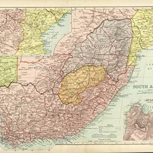
Cushion : Map of South Africa 1900


![]()
Home Decor from Fine Art Storehouse
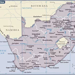
Map of South Africa 1900
Meyers hand-Atlas Leipzig und Wien Verlag des Bibliographischen Instituts 1900
Unleash your creativity and transform your space into a visual masterpiece!
THEPALMER
Media ID 18106903
© 2014 Roberto Adrian Photography
Cushion
Refresh your home decor with a beautiful full photo 16"x16" (40x40cm) cushion, complete with cushion pad insert. Printed on both sides and made from 100% polyester with a zipper on the bottom back edge of the cushion cover. Care Instructions: Warm machine wash, do not bleach, do not tumble dry. Warm iron inside out. Do not dry clean.
Accessorise your space with decorative, soft cushions
Estimated Product Size is 40cm x 40cm (15.7" x 15.7")
These are individually made so all sizes are approximate
Artwork printed orientated as per the preview above, with landscape (horizontal) or portrait (vertical) orientation to match the source image.
FEATURES IN THESE COLLECTIONS
> Africa
> Related Images
> Africa
> South Africa
> Maps
> Africa
> South Africa
> Related Images
> Fine Art Storehouse
> Map
> Historical Maps
EDITORS COMMENTS
In this print titled "Map of South Africa 1900" we are transported back in time to a pivotal era in the continent's history. The image, sourced from Meyers Hand-Atlas Leipzig und Wien Verlag des Bibliographischen Instituts 1900, offers us a glimpse into the intricate cartographic work of that period. The map itself is an exquisite representation of South Africa at the turn of the century, showcasing its diverse topography and geographical features. From the majestic Drakensberg Mountains to the expansive Kalahari Desert, every detail has been meticulously captured by THEPALMER's lens. As we explore this vintage piece, it becomes evident that it holds more than just geographic significance. It serves as a historical artifact, reminding us of the complex past that shaped South Africa during this particular time frame. It prompts reflection on colonialism and its impact on indigenous communities across the region. THEPALMER's skillful photography ensures that each line and contour is vividly preserved in this print. The sepia tones add an air of nostalgia, further enhancing our connection to a bygone era. Whether you are an avid historian or simply fascinated by maps' timeless allure, "Map of South Africa 1900" promises to be an intriguing addition to any collection. Its artistic merit lies not only in its aesthetic appeal but also in its ability to transport viewers through space and time – inviting contemplation about our shared human journey throughout history.
MADE IN AUSTRALIA
Safe Shipping with 30 Day Money Back Guarantee
FREE PERSONALISATION*
We are proud to offer a range of customisation features including Personalised Captions, Color Filters and Picture Zoom Tools
SECURE PAYMENTS
We happily accept a wide range of payment options so you can pay for the things you need in the way that is most convenient for you
* Options may vary by product and licensing agreement. Zoomed Pictures can be adjusted in the Cart.