Cushion > Africa > Guinea > Maps
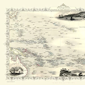
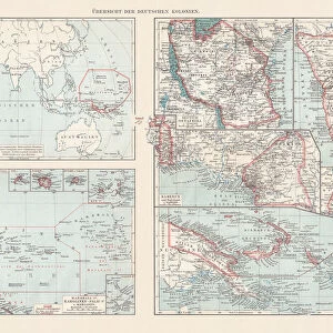
Cushion : Topographic maps of the former German colonies, lithograph, published 1897


![]()
Home Decor from Fine Art Storehouse
Topographic maps of the former German colonies, lithograph, published 1897
Topographic maps of the former German colonies in Africa and the South Seas. Lithograph, published in 1897
Unleash your creativity and transform your space into a visual masterpiece!
Media ID 15372257
© This content is subject to copyright
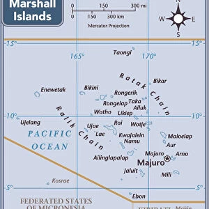
African Culture Atlantic Ocean Colonialism Colony Country Empire German Culture German Empire Island Mozambique Namibia Pacific Ocean Palau Papua New Guinea Togo Topographic Map Caroline Islands Mariana Islands Marshall Islands Multi Colored New Guinea South Sea
Cushion
Refresh your home decor with a beautiful full photo 16"x16" (40x40cm) cushion, complete with cushion pad insert. Printed on both sides and made from 100% polyester with a zipper on the bottom back edge of the cushion cover. Care Instructions: Warm machine wash, do not bleach, do not tumble dry. Warm iron inside out. Do not dry clean.
Accessorise your space with decorative, soft cushions
Estimated Product Size is 40cm x 40cm (15.7" x 15.7")
These are individually made so all sizes are approximate
Artwork printed orientated as per the preview above, with landscape (horizontal) or portrait (vertical) orientation to match the source image.
FEATURES IN THESE COLLECTIONS
> Africa
> Guinea
> Related Images
> Africa
> Mozambique
> Maps
> Africa
> Mozambique
> Related Images
> Africa
> Namibia
> Related Images
> Africa
> Related Images
> Africa
> South Africa
> Maps
> Africa
> South Africa
> Related Images
> Fine Art Storehouse
> Map
> Historical Maps
EDITORS COMMENTS
This lithograph from 1897 showcases topographic maps of the former German colonies in Africa and the South Seas. The intricate details of this print provide a glimpse into the vast territories once under German rule during the time of colonialism. With its blue and white hues, it exudes a sense of exploration and discovery. The map depicts various regions including Cameroon, Mozambique, Namibia, Togo, Marshall Islands, Caroline Islands, Mariana Islands, Papua New Guinea, Palau, and more. Each country's coastline is meticulously outlined along with their respective landscapes. The artist skillfully captures the diverse African culture through vibrant colors that represent different terrains. As we delve into this historical piece of artistry, we are transported to an era when Germany sought to expand its influence across oceans. The lithograph not only highlights Germany's imperial ambitions but also provides insight into their cultural impact on these distant lands. Displayed horizontally as an engraving on paper with multiple colors dominating its composition - notably red - this print offers a visual feast for those interested in cartography or exploring past empires' legacies. It serves as a reminder of how nations shaped history through colonization while simultaneously celebrating the beauty found within these far-flung corners of our world.
MADE IN AUSTRALIA
Safe Shipping with 30 Day Money Back Guarantee
FREE PERSONALISATION*
We are proud to offer a range of customisation features including Personalised Captions, Color Filters and Picture Zoom Tools
SECURE PAYMENTS
We happily accept a wide range of payment options so you can pay for the things you need in the way that is most convenient for you
* Options may vary by product and licensing agreement. Zoomed Pictures can be adjusted in the Cart.