Home > Science > Space Exploration > Planets > Earth
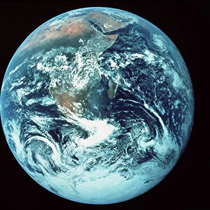
Whole Earth Centred On Pacific Ocean, True Colour Satellite Image Of The Earth

![]()
Wall Art and Photo Gifts from Design Pics
Whole Earth Centred On Pacific Ocean, True Colour Satellite Image Of The Earth
Whole Earth Centred On Pacific Ocean, True Colour Satellite Image. True colour satellite image of the whole Earth centred on the Pacific Ocean, with bump effect. This image in Miller projection was compiled from data acquired by LANDSAT 5 & 7 satell
Design Pics offers Distinctively Different Imagery representing over 1,500 contributors
Media ID 24589302
© UIG / Design Pics
Africa Antarctica Asia Daniel Earth Earth Science Environment Geographic Illustration Oceania Planet Planet Earth Relief Russelman Satellite Image Sciences Uig Premium 1 Uig1 Satellite And Aerial World
FEATURES IN THESE COLLECTIONS
> Aerial Photography
> America
> Aerial Photography
> Related Images
> Arts
> Artists
> O
> Oceanic Oceanic
> Design Pics
> Design Pics Art
> Design Pics
> Universal Images Group
> Design Pics
> Update - March 23, 2022
> Maps and Charts
> Related Images
> Maps and Charts
> World
> Science
> Space Exploration
> Planets
> Earth
EDITORS COMMENTS
This print showcases a true color satellite image of the Earth, with the Pacific Ocean at its center. The stunning visual is presented in a Miller projection, offering a unique perspective on our planet's diverse continents and vast oceans. Compiled from data acquired by LANDSAT 5 & 7 satellites, this image captures the intricate details of our world's natural beauty. The vibrant hues depict different regions across the globe, highlighting the environmental diversity that exists on Earth. From lush green forests to arid deserts, from icy polar caps to expansive oceans, this image encapsulates the remarkable variety found within our planet's ecosystems. The bump effect adds an extra dimension to this already mesmerizing portrayal of Earth. It enhances relief features such as mountains and valleys, giving viewers a sense of depth and texture. This artistic touch brings out the geological wonders that shape our landscapes. As we gaze upon this illustration, we are reminded of how interconnected all nations and continents truly are. It serves as a powerful symbol of unity among humanity while emphasizing our collective responsibility to protect and preserve our environment for future generations. This print is not just an aesthetic masterpiece; it also represents scientific advancements in satellite imaging technology. By capturing these breathtaking visuals from space, researchers can gain valuable insights into climate patterns, land use changes, and other vital aspects of Earth science.
MADE IN AUSTRALIA
Safe Shipping with 30 Day Money Back Guarantee
FREE PERSONALISATION*
We are proud to offer a range of customisation features including Personalised Captions, Color Filters and Picture Zoom Tools
SECURE PAYMENTS
We happily accept a wide range of payment options so you can pay for the things you need in the way that is most convenient for you
* Options may vary by product and licensing agreement. Zoomed Pictures can be adjusted in the Cart.