Home > Science > Space Exploration > Planets > Earth
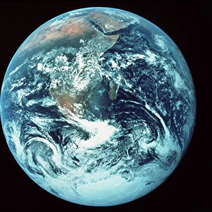
Globe Centred On The Americas, True Colour Satellite Image. True colour satellite image of the Earth centred on the Americas with cloud coverage, during summer solstice at 6 a. m GMT. This image in orthographic projection was compiled from data acquired by LANDSAT 5 & 7 satellites

![]()
Wall Art and Photo Gifts from Design Pics
Globe Centred On The Americas, True Colour Satellite Image. True colour satellite image of the Earth centred on the Americas with cloud coverage, during summer solstice at 6 a. m GMT. This image in orthographic projection was compiled from data acquired by LANDSAT 5 & 7 satellites
Globe Centred On The Americas, True Colour Satellite Image. True colour satellite image of the Earth centred on the Americas with cloud coverage, during summer solstice at 6 a.m GMT. This image in orthographic projection was compiled from data acquired by LANDSAT 5 & 7 satellites
Design Pics offers Distinctively Different Imagery representing over 1,500 contributors
Media ID 24589080
© UIG / Design Pics
Atlantic Ocean Caribbean Earth Earth Science Environment Geographic Illustration Globe North Pacific Ocean Planet Planet Earth Relief Satellite Satellite Image Sciences South America Space Uig Premium 1 Uig1 Satellite And Aerial World
FEATURES IN THESE COLLECTIONS
> Aerial Photography
> America
> Aerial Photography
> Related Images
> Arts
> Artists
> O
> Oceanic Oceanic
> Design Pics
> Design Pics Art
> Design Pics
> Universal Images Group
> Design Pics
> Update - March 23, 2022
> Maps and Charts
> Related Images
> Maps and Charts
> World
> Science
> Space Exploration
> Planets
> Earth
> South America
> Related Images
EDITORS COMMENTS
This print showcases a true colour satellite image of the Earth, with the Americas at its center. Taken during the summer solstice at 6 a. m GMT, this stunning image provides a unique perspective of our planet's cloud coverage. Compiled from data acquired by LANDSAT 5 & 7 satellites, this orthographic projection offers an accurate representation of our world. The vibrant illustration captures the beauty and diversity of the Americas, stretching from North to South America. The relief on the map highlights various geographical features such as mountain ranges and coastlines, while the Caribbean Sea and Pacific and Atlantic Oceans add depth to this mesmerizing view. As we gaze upon this remarkable satellite image, we are reminded of both the vastness and interconnectedness of our planet. It serves as a testament to human ingenuity in capturing such intricate details from space. This photograph is not just visually striking but also holds scientific significance. It falls under earth science research that aids in understanding weather patterns, climate change, and environmental studies. Whether you're an enthusiast for space exploration or simply appreciate Earth's natural wonders, this print invites you to explore our world from a different perspective. Let it inspire awe for our beautiful home planet and encourage us all to cherish and protect it for future generations.
MADE IN AUSTRALIA
Safe Shipping with 30 Day Money Back Guarantee
FREE PERSONALISATION*
We are proud to offer a range of customisation features including Personalised Captions, Color Filters and Picture Zoom Tools
SECURE PAYMENTS
We happily accept a wide range of payment options so you can pay for the things you need in the way that is most convenient for you
* Options may vary by product and licensing agreement. Zoomed Pictures can be adjusted in the Cart.