Home > Arts > Realistic drawings > Still life artwork > Fine art
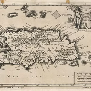
Map Of EspaAnola With The Columbine Forts And Settlements. From The Book Life Of Christopher Columbus By Clements R. Markham Published 1892

![]()
Wall Art and Photo Gifts from Design Pics
Map Of EspaAnola With The Columbine Forts And Settlements. From The Book Life Of Christopher Columbus By Clements R. Markham Published 1892
Design Pics offers Distinctively Different Imagery representing over 1,500 contributors
Media ID 18177174
© Hilary Jane Morgan / Design Pics
Cartography Chart Christopher Colon Colonies Colony Columbine Columbus Cristobal Cristoval Dominican Forts Geographical Geography Mapmaking New World Republic Settlements Voyage World Espanola
FEATURES IN THESE COLLECTIONS
> Arts
> Realistic drawings
> Still life artwork
> Fine art
> Design Pics
> Design Pics Art
> Art llustrations and Engravings
> Maps and Charts
> Related Images
> Maps and Charts
> World
> North America
> Dominican Republic
> Maps
> North America
> Dominican Republic
> Related Images
EDITORS COMMENTS
This print showcases a historical map titled "Map Of EspaAnola With The Columbine Forts And Settlements". Published in 1892 by Clements R. Markham, this exquisite piece of cartography takes us back to the era of Christopher Columbus and his monumental voyage to the New World. The map depicts the island of EspaAnola, now known as Hispaniola, with intricate details of forts and settlements established during Columbus' expedition. It offers a fascinating glimpse into the geographical layout and colonial presence on this significant landmass. As we delve into this visual treasure trove, we are transported to an era when exploration was at its peak. The chart not only serves as a testament to Christopher Columbus' audacious journey but also highlights the remarkable advancements in mapmaking during that time. With its vibrant colors and meticulous craftsmanship, this print captures our imagination and invites us to embark on our own voyage through history. It reminds us of the brave souls who ventured into uncharted territories, shaping new republics and colonies along their way. Hilary Jane Morgan's careful preservation of this valuable artifact allows us to appreciate both its artistic beauty and historical significance. This print is a must-have for any enthusiast seeking an authentic connection with the past – a tangible reminder of humanity's insatiable thirst for discovery.
MADE IN AUSTRALIA
Safe Shipping with 30 Day Money Back Guarantee
FREE PERSONALISATION*
We are proud to offer a range of customisation features including Personalised Captions, Color Filters and Picture Zoom Tools
SECURE PAYMENTS
We happily accept a wide range of payment options so you can pay for the things you need in the way that is most convenient for you
* Options may vary by product and licensing agreement. Zoomed Pictures can be adjusted in the Cart.