Home > Arts > Realistic drawings > Still life artwork > Fine art
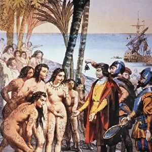
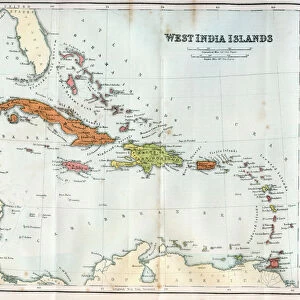
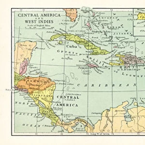
Map Of Guanahani Or San Salvador Showing Watling Island Where Christopher Columbus Made Landfall In 1492. From The Book Life Of Christopher Columbus By Clements R. Markham Published 1892

![]()
Wall Art and Photo Gifts from Design Pics
Map Of Guanahani Or San Salvador Showing Watling Island Where Christopher Columbus Made Landfall In 1492. From The Book Life Of Christopher Columbus By Clements R. Markham Published 1892
Design Pics offers Distinctively Different Imagery representing over 1,500 contributors
Media ID 18177182
© Hilary Jane Morgan / Design Pics
1492 Bahamas Cartography Chart Christopher Colon Columbus Cristobal Cristoval Geographical Geography Grand Mapmaking Turk World Caicos Guanahani Landfall Salvador Samana Watling
FEATURES IN THESE COLLECTIONS
> Arts
> Realistic drawings
> Still life artwork
> Fine art
> Design Pics
> Design Pics Art
> Art llustrations and Engravings
> Maps and Charts
> Related Images
> Maps and Charts
> World
> North America
> The Bahamas
> Maps
> North America
> The Bahamas
> Related Images
> North America
> El Salvador
> Maps
> North America
> El Salvador
> San Salvador
> North America
> Turks and Caicos
> Maps
EDITORS COMMENTS
This print showcases a historical map of Guanahani or San Salvador, revealing the exact location where Christopher Columbus first set foot in 1492. With intricate details and precise cartography, this vintage map from the book "Life of Christopher Columbus" by Clements R. Markham takes us back to a significant moment in history. The map highlights Watling Island, now known as San Salvador Island, which served as Columbus' initial landfall during his voyage across the Atlantic Ocean. The grand island is depicted with stunning accuracy, allowing us to visualize the geographical features that greeted Columbus upon his arrival. Immerse yourself in this remarkable piece of artistry and explore the Bahamian archipelago through the eyes of early explorers. From Turk and Caicos Islands to Samana Cay and Mayaguana, each island is meticulously marked on this charted masterpiece. As we examine this extraordinary mapmaking achievement by Hilary Jane Morgan, we are reminded of Christopher Columbus's audacious spirit and determination to navigate uncharted territories. This image not only serves as a testament to his historic journey but also celebrates the rich heritage and cultural significance of these islands. Whether you are an avid collector or simply fascinated by world geography, this print offers an opportunity to own a piece of history while appreciating the beauty found within maps themselves.
MADE IN AUSTRALIA
Safe Shipping with 30 Day Money Back Guarantee
FREE PERSONALISATION*
We are proud to offer a range of customisation features including Personalised Captions, Color Filters and Picture Zoom Tools
SECURE PAYMENTS
We happily accept a wide range of payment options so you can pay for the things you need in the way that is most convenient for you
* Options may vary by product and licensing agreement. Zoomed Pictures can be adjusted in the Cart.