Home > Aerial Photography > Austria
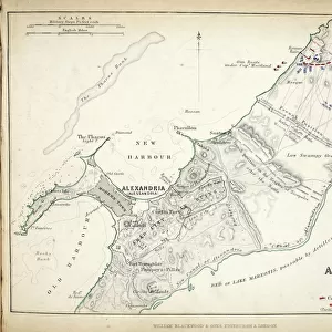
Map of the Battles of Turcoing & Tournay, published by William Blackwood and Sons

![]()
Wall Art and Photo Gifts from Fine Art Finder
Map of the Battles of Turcoing & Tournay, published by William Blackwood and Sons
746874 Map of the Battles of Turcoing & Tournay, published by William Blackwood and Sons, Edinburgh & London, 1848 (hand-coloured engraving) by Johnston, Alexander Keith (1804-71); Private Collection; (add.info.: Battle of Tourcoing (18 May 1794). Battle of Tournay (22 May 1794).); The Stapleton Collection; Scottish, out of copyright
Media ID 23165924
© The Stapleton Collection / Bridgeman Images
Aerial View Armies Cartography French Revolutionary Wars Mapping Positions War Of The First Coalition Austria Austrian Austrians
FEATURES IN THESE COLLECTIONS
> Aerial Photography
> Austria
> Arts
> Artists
> Related Images
> Europe
> Austria
> Aerial Views
> Europe
> United Kingdom
> England
> London
> Related Images
> Europe
> United Kingdom
> Scotland
> Edinburgh
> Edinburgh
> Europe
> United Kingdom
> Scotland
> Lothian
> Edinburgh
> Fine Art Finder
> Artists
> Alexander Keith Johnston
> Fine Art Finder
> Maps (celestial & Terrestrial)
EDITORS COMMENTS
This print showcases the "Map of the Battles of Turcoing & Tournay" a historical artifact published by William Blackwood and Sons in 1848. The hand-colored engraving, created by Alexander Keith Johnston, provides a detailed aerial view of the Flanders campaign during the French Revolutionary Wars in the late 18th century. The map highlights key positions and movements of armies from Great Britain, Austria, and France during two significant battles: Tourcoing on May 18,1794, and Tournay on May 22,1794. These clashes were part of the War of the First Coalition against revolutionary France. Through meticulous mapping techniques employed by Johnston, this engraving offers an invaluable resource for understanding military strategies used by various European powers at that time. It serves as a testament to both his cartographic skills and his dedication to documenting history. As we explore this piece further, it becomes evident that this map transcends its original purpose as a tool for military analysis. Its intricate details evoke curiosity about Europe's past conflicts while also reminding us of our shared heritage within the European Union today. Preserved within a private collection but made available through Bridgeman Images' fine art finder platform, this remarkable print invites viewers to delve into an era marked by political upheaval and territorial disputes. It stands as a testament to how art can preserve history and ignite our imagination with stories from centuries gone by.
MADE IN AUSTRALIA
Safe Shipping with 30 Day Money Back Guarantee
FREE PERSONALISATION*
We are proud to offer a range of customisation features including Personalised Captions, Color Filters and Picture Zoom Tools
SECURE PAYMENTS
We happily accept a wide range of payment options so you can pay for the things you need in the way that is most convenient for you
* Options may vary by product and licensing agreement. Zoomed Pictures can be adjusted in the Cart.