Home > Animals > Insects > Hemiptera > Black Scale
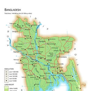
Bay of Bengal from Ceylon to Malacca, 1758 (coloured engraving)
")
![]()
Wall Art and Photo Gifts from Fine Art Finder
Bay of Bengal from Ceylon to Malacca, 1758 (coloured engraving)
7339374 Bay of Bengal from Ceylon to Malacca, 1758 (coloured engraving) by Herbert, William (fl.c.1758); 65x95 cm; National Maritime Museum, London, UK; (add.info.: Creator: [William Herbert]
Single sheet. Hand col. engr. Scale: [ca. 1:4 500 000]. Cartographic Note: Borders graaduated for latitude. No variation. Soundings. Additional Places: Andaman Sea, Sri Lanka, India, Bangladesh, Myanmar, Malaysia, Sumatra.); © National Maritime Museum, Greenwich, London
Media ID 38176998
© © National Maritime Museum, Greenwich, London / Bridgeman Images
Asiae Bangladesh Bangladeshi Bengal Burma Burma Burmese Cartography Indonesia Indonesia Indonesian Indonesian Malaysia Malaysian Myanmar South East Asia Sri Lanka Sri Lankan Sumatra West Bengal
FEATURES IN THESE COLLECTIONS
> Animals
> Insects
> Hemiptera
> Black Scale
> Arts
> Artists
> W
> William White
> Asia
> Bangladesh
> Maps
> Asia
> Bangladesh
> Related Images
> Asia
> Indonesia
> Related Images
> Asia
> Malaysia
> Related Images
> Fine Art Finder
> Artists
> Alexis-Hubert Jaillot
> Fine Art Finder
> Artists
> William Herbert 'Buck' Dunton
EDITORS COMMENTS
This stunning coloured engraving from 1758 captures the vast expanse of the Bay of Bengal, stretching from Ceylon to Malacca. The intricate details and vibrant colors bring to life a snapshot of maritime navigation in the 18th century.
Created by William Herbert, this map showcases borders graduated for latitude, soundings, and additional places such as the Andaman Sea, Sri Lanka, India, Bangladesh, Myanmar, Malaysia, and Sumatra. The scale of approximately 1:4 500 000 provides a comprehensive view of this important region in Asia during that time period.
The historical significance of this print cannot be understated - it offers a glimpse into the cartography and exploration efforts of the era. From trade routes to geopolitical boundaries, every detail on this map tells a story of seafaring adventures and cultural exchanges between nations.
As you gaze upon this piece hanging proudly on your wall or displayed in your home or office space, let yourself be transported back in time to an age when maps were not just tools for navigation but works of art that captured the imagination and curiosity of explorers around the world.
MADE IN AUSTRALIA
Safe Shipping with 30 Day Money Back Guarantee
FREE PERSONALISATION*
We are proud to offer a range of customisation features including Personalised Captions, Color Filters and Picture Zoom Tools
SECURE PAYMENTS
We happily accept a wide range of payment options so you can pay for the things you need in the way that is most convenient for you
* Options may vary by product and licensing agreement. Zoomed Pictures can be adjusted in the Cart.