Home > Arts > Artists > H > William Hodges
ii. (a) Four profiles of the coast of Terra del Fuego (b
 Four profiles of the coast of Terra del Fuego (b")
![]()
Wall Art and Photo Gifts from Fine Art Finder
ii. (a) Four profiles of the coast of Terra del Fuego (b
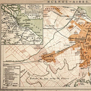
5670247 ii. (a) Four profiles of the coast of Terra del Fuego (b) A plan of Success Bay in Strait le Maire (c) A chart of the S.E. part of Terra del Fuego, engraved by T. Borven and J. Gibson, 1769 (engraving) by Cook, James (1728-79); Mitchell Library, State Library of New South Wales; (add.info.: Original Sketches, Drawings, Maps etc Collected by Admiral Isaac Smith / drawings and watercolours, mainly of Captain Cooks Second Voyage (1772-1775) by William Hodges, Henry Roberts etc
Dimensions: Album measures 49 x 70 cm); Mitchell Library, State Library of New South Wales; English, out of copyright
Media ID 22566276
© Mitchell Library, State Library of New South Wales / Bridgeman Images
Archipelago Argentina Argentine Argentinian Captain Cook Cartographic Cartography Chart Elevation Engraved Expedition Geographical Hydrographic Islands Land Mapping Monochrome Numbered Numbers South East South Eastern Survey Surveying Tierra Del Fuego Voyage Le Maire Strait
FEATURES IN THESE COLLECTIONS
> Arts
> Artists
> H
> William Hodges
> Arts
> Minimalist artwork
> Monochrome artwork
> Fine art
> Arts
> Minimalist artwork
> Monochrome artwork
> Monochrome paintings
> Europe
> United Kingdom
> Wales
> Maps
> Fine Art Finder
> Artists
> Company Byron
> Fine Art Finder
> Artists
> James Cook
> Maps and Charts
> Wales
> South America
> Argentina
> Maps
EDITORS COMMENTS
The print titled "ii. (a) Four profiles of the coast of Terra del Fuego (b) A plan of Success Bay in Strait le Maire (c) A chart of the S. E. part of Terra del Fuego" captures a remarkable piece of cartographic history. Engraved by T. Borven and J. Gibson in 1769, this engraving showcases the meticulous surveying and mapping work conducted by Captain James Cook during his second voyage from 1772 to 1775. The image reveals four detailed profiles of the coastline, providing a visual representation of the elevation and mountainous terrain found along Terra del Fuego's shores. The archipelago's rugged beauty is further highlighted through an intricately designed plan depicting Success Bay in Strait le Maire. This historical artifact offers valuable insights into early exploration efforts as it showcases Captain Cook's expeditionary route through South America, specifically Argentina's southernmost region. The map also includes various numbered islands within its boundaries, contributing to our understanding of geographical features discovered during this period. Preserved at Mitchell Library, State Library of New South Wales, this engraving serves as a testament to Captain Cook's pioneering spirit and his significant contributions to maritime exploration during the eighteenth century. It stands as a reminder not only of his first voyage but also highlights the importance placed on accurate cartography for future expeditions that followed. Overall, this print provides viewers with an opportunity to delve into history while appreciating both the artistic skill involved in creating such maps and their scientific significance for navigation purposes centuries ago.
MADE IN AUSTRALIA
Safe Shipping with 30 Day Money Back Guarantee
FREE PERSONALISATION*
We are proud to offer a range of customisation features including Personalised Captions, Color Filters and Picture Zoom Tools
SECURE PAYMENTS
We happily accept a wide range of payment options so you can pay for the things you need in the way that is most convenient for you
* Options may vary by product and licensing agreement. Zoomed Pictures can be adjusted in the Cart.