Home > North America > United States of America > New York > New York > Sights > New York Public Library
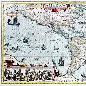
Virginiae item et Floridae Americae provinciarum, nova descriptio

![]()
Wall Art and Photo Gifts from Fine Art Finder
Virginiae item et Floridae Americae provinciarum, nova descriptio
5242474 Virginiae item et Floridae Americae provinciarum, nova descriptio, 1636 (colour engraving) by Hondius, Jodocus (1567-1611); New York Public Library, USA; (add.info.: Map first published 1606 by Hendrik Hondius (1597-1651) from an English edition of Mercators Atlas from the Spanish colony of St Augustine to Chesapeak Bay); Dutch, out of copyright
Media ID 22567262
© Bridgeman Images
Americas Atlas Canoe Carolina Cartography Colony Compass Flemish Florida Geographical Gerard Mercator Lakes Native Americans New World Sea Monster Topographical Virginia Appalachian Mountains Appalachians Floridian Hondius Mercator Rulers
FEATURES IN THESE COLLECTIONS
> Arts
> Artists
> H
> Hendrik Hondius
> Arts
> Artists
> H
> Jodocus Hondius
> Arts
> Landscape paintings
> Waterfall and river artworks
> River artworks
> Fine Art Finder
> Artists
> Detroit Publishing Co
> Fine Art Finder
> Artists
> Jodocus Hondius
> Maps and Charts
> World
> North America
> United States of America
> Florida
> Related Images
> North America
> United States of America
> Lakes
> Related Images
> North America
> United States of America
> Maps
> North America
> United States of America
> New York
> New York
> Maps
> North America
> United States of America
> New York
> New York
> Sights
> New York Public Library
EDITORS COMMENTS
This print showcases the intricate and detailed map titled "Virginiae item et Floridae Americae provinciarum, nova descriptio" by Jodocus Hondius. Created in 1636, this color engraving offers a fascinating glimpse into the early exploration of North America. The map depicts the Spanish colony of St. Augustine to Chesapeake Bay, highlighting the geographical features and colonial settlements along the coastline. It is adorned with decorative elements such as sea monsters, compasses, and rulers that add an ornate touch to its overall design. As we delve into this historical artwork, we can observe various aspects of discovery and transportation during that era. Canoes and boats gracefully glide across rivers and lakes while a majestic ship dominates the seas. The presence of native Americans signifies their connection to these lands long before European colonization took place. With its meticulous attention to detail, this map serves as both a cartographic representation and a work of art. It reflects not only the Dutch influence but also Gerard Mercator's original atlas from which it was derived. Preserved by the New York Public Library, this print allows us to appreciate Hondius' craftsmanship while offering insights into early American history. Whether you are fascinated by cartography or simply intrigued by our ancestors' explorations, this image transports you back in time to an era filled with curiosity and adventure.
MADE IN AUSTRALIA
Safe Shipping with 30 Day Money Back Guarantee
FREE PERSONALISATION*
We are proud to offer a range of customisation features including Personalised Captions, Color Filters and Picture Zoom Tools
SECURE PAYMENTS
We happily accept a wide range of payment options so you can pay for the things you need in the way that is most convenient for you
* Options may vary by product and licensing agreement. Zoomed Pictures can be adjusted in the Cart.