Home > North America > Puerto Rico > Maps
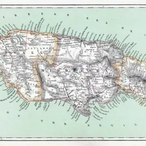
Geography map: representation of the islands of the Greater Antilles (Cuba, Hispaniola, Jamaica and Puerto Rico) and the Lesser Antilles in the Caribbean Sea. Engraved board from an Atlas of the 18th century. Biblioteca Angelica, Rome
 and the Lesser Antilles in the Caribbean Sea. Engraved board from an Atlas of the 18th century. Biblioteca Angelica, Rome")
![]()
Wall Art and Photo Gifts from Fine Art Finder
Geography map: representation of the islands of the Greater Antilles (Cuba, Hispaniola, Jamaica and Puerto Rico) and the Lesser Antilles in the Caribbean Sea. Engraved board from an Atlas of the 18th century. Biblioteca Angelica, Rome
VEN5030434 Geography map: representation of the islands of the Greater Antilles (Cuba, Hispaniola, Jamaica and Puerto Rico) and the Lesser Antilles in the Caribbean Sea. Engraved board from an Atlas of the 18th century. Biblioteca Angelica, Rome; (add.info.: Geography map: representation of the islands of the Greater Antilles (Cuba, Hispaniola, Jamaica and Puerto Rico) and the Lesser Antilles in the Caribbean Sea. Engraved board from an Atlas of the 18th century. Biblioteca Angelica, Rome); © Marage Photos
Media ID 38350294
© © Marage Photos / Bridgeman Images
Amerique (continent) Amerique Centrale Amerique Du Nord Caraïbes Caribbean Caribbean Island Carte Geographique Central America Cuba Cuba Cubain Cubaine Cubains Cubaines Cuban Etats Unis Geographie Jamaica Jamaican Stockravenna
FEATURES IN THESE COLLECTIONS
> Fine Art Finder
> Artists
> Francois Xavier Fabre
> Maps and Charts
> Early Maps
> North America
> Cuba
> Maps
> North America
> Cuba
> Related Images
> North America
> Jamaica
> Maps
> North America
> Jamaica
> Related Images
> North America
> Puerto Rico
> Maps
> North America
> Puerto Rico
> Related Images
> North America
> United States of America
> Maps
> Popular Themes
> North Island
EDITORS COMMENTS
This stunning 18th-century engraving from the Biblioteca Angelica in Rome showcases a detailed geography map of the islands of the Greater Antilles and Lesser Antilles in the Caribbean Sea. The intricate representation includes Cuba, Hispaniola, Jamaica, and Puerto Rico among others, providing a historical glimpse into the layout of these iconic islands.
The delicate craftsmanship of this engraved board is evident in every line and detail, capturing the essence of each island with precision. The map serves as a valuable resource for understanding the geographical makeup of this region during that time period.
As you study this print, you can't help but be transported back to an era when exploration and discovery were at their peak. The significance of these islands in shaping history and culture is palpable through this visual depiction.
Whether you have a personal connection to these islands or simply appreciate their beauty from afar, this geography map offers a unique perspective on their importance in the Caribbean Sea. It's not just a piece of art; it's a window into another world waiting to be explored and understood.
MADE IN AUSTRALIA
Safe Shipping with 30 Day Money Back Guarantee
FREE PERSONALISATION*
We are proud to offer a range of customisation features including Personalised Captions, Color Filters and Picture Zoom Tools
SECURE PAYMENTS
We happily accept a wide range of payment options so you can pay for the things you need in the way that is most convenient for you
* Options may vary by product and licensing agreement. Zoomed Pictures can be adjusted in the Cart.