Home > Arts > Artists > B > Willem Blaeu
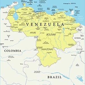
Geography map: representation of Venezuela in South America from an Atlas made by cartographer Willem Janszoon Blaeu (1571-1638), approximately 1630 Biblioteca Angelica, Rome
, approximately 1630 Biblioteca Angelica, Rome")
![]()
Wall Art and Photo Gifts from Fine Art Finder
Geography map: representation of Venezuela in South America from an Atlas made by cartographer Willem Janszoon Blaeu (1571-1638), approximately 1630 Biblioteca Angelica, Rome
VEN5030346 Geography map: representation of Venezuela in South America from an Atlas made by cartographer Willem Janszoon Blaeu (1571-1638), approximately 1630 Biblioteca Angelica, Rome; (add.info.: Geography map: representation of Venezuela in South America from an Atlas made by cartographer Willem Janszoon Blaeu (1571-1638), approximately 1630 Biblioteca Angelica, Rome); © Marage Photos
Media ID 38350288
© © Marage Photos / Bridgeman Images
17eme Siecle Amerique (continent) Amerique Du Nord Amerique Du Sud Carte Geographique Etats Unis Geographie Latin America Stockravenna Venezuela Venezuelan
FEATURES IN THESE COLLECTIONS
> Arts
> Artists
> B
> Willem Blaeu
> Fine Art Finder
> Artists
> Francois Xavier Fabre
> Maps and Charts
> Early Maps
> North America
> United States of America
> Maps
> South America
> Venezuela
> Maps
> South America
> Venezuela
> Related Images
EDITORS COMMENTS
This stunning print captures a detailed geography map of Venezuela in South America, created by the renowned cartographer Willem Janszoon Blaeu in approximately 1630. The intricate details and accuracy of this representation showcase the skill and expertise of Blaeu, who was known for his exceptional cartographic work during the 17th century.
The map is part of an Atlas housed in the Biblioteca Angelica in Rome, providing a glimpse into historical geographical knowledge and exploration from that time period. The rich colors and fine lines used to depict Venezuela highlight the beauty and complexity of this South American country.
As we study this map, we are transported back in time to an era when cartographers meticulously charted unknown territories, expanding our understanding of the world around us. The inclusion of Venezuela within this atlas serves as a reminder of the importance of geography in shaping our perceptions and interactions with different regions.
Overall, this print not only showcases a piece of history but also invites us to appreciate the artistry and dedication that went into creating such detailed maps centuries ago. It is a testament to human curiosity and ingenuity that continues to inspire exploration and discovery today.
MADE IN AUSTRALIA
Safe Shipping with 30 Day Money Back Guarantee
FREE PERSONALISATION*
We are proud to offer a range of customisation features including Personalised Captions, Color Filters and Picture Zoom Tools
SECURE PAYMENTS
We happily accept a wide range of payment options so you can pay for the things you need in the way that is most convenient for you
* Options may vary by product and licensing agreement. Zoomed Pictures can be adjusted in the Cart.