Home > Arts > Artists > C > Samuel de Champlain
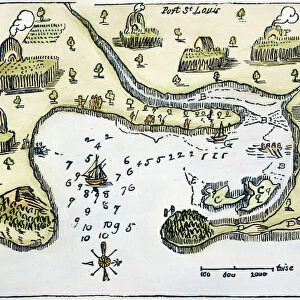
The map of Samuel de Champlain (1567-1635) of the colony of Tadoussac (Quebec) in 1613, on the St. Lawrence River and the Saguenay River, New France (Canada), the first French settlement in North America, north of Florida (United States)
 of the colony of Tadoussac (Quebec) in 1613, on the St. Lawrence River and the Saguenay River, New France (Canada), the first French settlement in North America, north of Florida (United States)")
![]()
Wall Art and Photo Gifts from Fine Art Finder
The map of Samuel de Champlain (1567-1635) of the colony of Tadoussac (Quebec) in 1613, on the St. Lawrence River and the Saguenay River, New France (Canada), the first French settlement in North America, north of Florida (United States)
NWI4849766 The map of Samuel de Champlain (1567-1635) of the colony of Tadoussac (Quebec) in 1613, on the St. Lawrence River and the Saguenay River, New France (Canada), the first French settlement in North America, north of Florida (United States). Color lithography, 19th century.; (add.info.: The map of Samuel de Champlain (1567-1635) of the colony of Tadoussac (Quebec) in 1613, on the St. Lawrence River and the Saguenay River, New France (Canada), the first French settlement in North America, north of Florida (United States). Color lithography, 19th century.); Photo © North Wind Pictures
Media ID 38103858
© Photo © North Wind Pictures / Bridgeman Images
America Continent Champlain Geographical Map Northwind Quebec
FEATURES IN THESE COLLECTIONS
> Arts
> Artists
> C
> Samuel de Champlain
> Arts
> Artists
> L
> Samuel Lawrence
> Fine Art Finder
> Artists
> George Pechell (after) Mends
> North America
> Canada
> Maps
> North America
> United States of America
> Florida
> Related Images
> North America
> United States of America
> Maps
EDITORS COMMENTS
This stunning print showcases the historic map of Samuel de Champlain's colony of Tadoussac in Quebec, dating back to 1613. The intricate details and vibrant colors bring to life the first French settlement in North America, situated on the picturesque St. Lawrence River and Saguenay River.
Samuel de Champlain, a renowned explorer and cartographer, played a crucial role in establishing this early French presence in what would later become Canada. His meticulous mapping skills are evident in this 19th-century lithograph, which captures the essence of New France during that time period.
As we gaze upon this map, we are transported back to a time of exploration and colonialism, when new lands were being discovered and settled by intrepid adventurers like Champlain. The rich history and geography depicted on this map offer us a glimpse into the past, allowing us to appreciate the legacy left behind by those who came before us.
From the rugged coastlines of Quebec to the vast wilderness beyond, this map serves as a reminder of the enduring spirit of discovery that has shaped North America for centuries. It is a testament to Champlain's pioneering efforts and his lasting impact on the landscape he helped chart with such precision.
MADE IN AUSTRALIA
Safe Shipping with 30 Day Money Back Guarantee
FREE PERSONALISATION*
We are proud to offer a range of customisation features including Personalised Captions, Color Filters and Picture Zoom Tools
SECURE PAYMENTS
We happily accept a wide range of payment options so you can pay for the things you need in the way that is most convenient for you
* Options may vary by product and licensing agreement. Zoomed Pictures can be adjusted in the Cart.