Home > Africa > Sudan > Maps
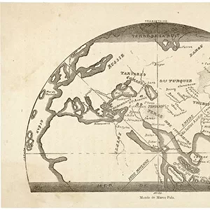
World map of the Arab geographer and cartographer Muhammad al-Idrisi, 1150 (engraving)
")
![]()
Wall Art and Photo Gifts from Fine Art Finder
World map of the Arab geographer and cartographer Muhammad al-Idrisi, 1150 (engraving)
3647375 World map of the Arab geographer and cartographer Muhammad al-Idrisi, 1150 (engraving) by German School, (19th century); Private Collection; (add.info.: World map of the Arab geographer and cartographer Muhammad al-Idrisi, 1150. Illustration for Weltgeschichte Fur Das Volk by Otto von Corvin and Wilhelm Held (Verlag und Druck von Otto Spamer, 1880). Digitally cleaned image.); © Look and Learn
Media ID 23642672
© Look and Learn / Bridgeman Images
Arab Culture Arabs Cartographer Cartography Du Soudan Geographer Afica Afric Arab Civilization Arabians Central Africa Sudan
FEATURES IN THESE COLLECTIONS
> Arts
> Art Movements
> Medieval Art
> Arts
> Artists
> Related Images
> Arts
> Street art graffiti
> Digital art
> Digital paintings
> Europe
> United Kingdom
> Scotland
> Highlands
> Alness
> Fine Art Finder
> Artists
> German School
> Fine Art Finder
> Artists
> Henry Morley
> Maps and Charts
> Early Maps
> Maps and Charts
> Related Images
EDITORS COMMENTS
This print showcases the intricate and historically significant "World map of the Arab geographer and cartographer Muhammad al-Idrisi, 1150". Created by the German School in the 19th century, this engraving is a testament to both artistic skill and intellectual curiosity. The map itself represents a pivotal moment in history, as it was crafted during the Middle Ages by Muhammad al-Idrisi, an esteemed Arab geographer. It offers a unique perspective on the world as understood at that time, providing valuable insights into medieval geography. With its detailed depictions of various regions across Africa and beyond, this map serves as a fascinating window into Arab civilization's rich cultural heritage. The inclusion of Sudan highlights Africa's importance within this historical context. Notably, this image has been digitally cleaned to enhance its clarity while preserving its authenticity. Its presence in private collections speaks to its value as both an educational resource and a work of art. As we explore this remarkable piece from Bridgeman Images' Fine Art Finder collection, we are reminded of how maps have shaped our understanding of the world throughout history. This particular print invites us to delve deeper into the past while appreciating the ingenuity and contributions of figures like Muhammad al-Idrisi.
MADE IN AUSTRALIA
Safe Shipping with 30 Day Money Back Guarantee
FREE PERSONALISATION*
We are proud to offer a range of customisation features including Personalised Captions, Color Filters and Picture Zoom Tools
SECURE PAYMENTS
We happily accept a wide range of payment options so you can pay for the things you need in the way that is most convenient for you
* Options may vary by product and licensing agreement. Zoomed Pictures can be adjusted in the Cart.