Home > Arts > Artists > S > Spanish School
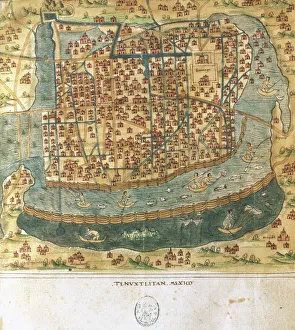
Map of Tenochtitlan and the Gulf of Mexico, from Praeclara Ferdinadi Cortesii de

![]()
Wall Art and Photo Gifts from Fine Art Finder
Map of Tenochtitlan and the Gulf of Mexico, from Praeclara Ferdinadi Cortesii de
NBY259415 Map of Tenochtitlan and the Gulf of Mexico, from Praeclara Ferdinadi Cortesii de Nova maris Oceani Hyspania Narratio by Hernando Cortes (1485-1547) 1524 (colour litho) by Spanish School, (16th century); Newberry Library, Chicago, Illinois, USA; eNewberry Library; Spanish, out of copyright
Media ID 23380224
© Newberry Library / Bridgeman Images
Aztec Capital Cartography Chart Conquistadors Hernan Mexico City
FEATURES IN THESE COLLECTIONS
> Arts
> Artists
> S
> Spanish School
> Fine Art Finder
> Artists
> James Peachey
> Fine Art Finder
> Artists
> Spanish School (after)
> Fine Art Finder
> Maps (celestial & Terrestrial)
> Maps and Charts
> Early Maps
> North America
> Mexico
> Maps
> North America
> Mexico
> Mexico City
> North America
> United States of America
> Illinois
> Chicago
> North America
> United States of America
> Maps
EDITORS COMMENTS
This print showcases a historic map titled "Map of Tenochtitlan and the Gulf of Mexico" from the renowned book "Praeclara Ferdinadi Cortesii de Nova maris Oceani Hyspania Narratio" by Hernando Cortes. Created in 1524, this colorful lithograph provides a fascinating glimpse into the early exploration and conquests of Mexico City. The map depicts the magnificent city of Tenochtitlan, which was once situated on an island in Lake Texcoco. It also encompasses the surrounding areas, including the vast Gulf of Mexico. The intricate details and precise cartography offer valuable insights into the layout and structure of this ancient Aztec capital. As we delve into history through this image, we are transported back to a time when Spanish conquistadors like Hernan Cortes embarked on expeditions to discover new lands. This visual representation serves as both a chart for navigation and an invaluable historical document that sheds light on early encounters between different civilizations. Preserved at Newberry Library in Chicago, Illinois, USA, this remarkable piece is part of their extensive collection showcasing significant works from various periods. Through Bridgeman Images' reproduction, viewers can appreciate not only its artistic beauty but also gain knowledge about past cultures and explorations. With its vibrant colors and meticulous detailing, this print invites us to explore our world's rich history while marveling at the achievements made by those who came before us.
MADE IN AUSTRALIA
Safe Shipping with 30 Day Money Back Guarantee
FREE PERSONALISATION*
We are proud to offer a range of customisation features including Personalised Captions, Color Filters and Picture Zoom Tools
SECURE PAYMENTS
We happily accept a wide range of payment options so you can pay for the things you need in the way that is most convenient for you
* Options may vary by product and licensing agreement. Zoomed Pictures can be adjusted in the Cart.