Home > Arts > Artists > W > Frederick de Wit
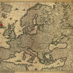
Map of the Belgian Federation (Belgium) (etching, 1671)
 (etching, 1671)")
![]()
Wall Art and Photo Gifts from Fine Art Finder
Map of the Belgian Federation (Belgium) (etching, 1671)
LRI4710774 Map of the Belgian Federation (Belgium) (etching, 1671) by Wit, Frederick de (1630-1706); Private Collection; (add.info.: Map of the Belgian Federation (Belgium) - Strong water extracted from " Theatrum Orbis", 1671, by Frederick De Wit (Frederico de Witt) (1630-1706)); Luisa Ricciarini; Dutch, out of copyright
Media ID 22467826
© Luisa Ricciarini / Bridgeman Images
Atlas Book Flemish Region Walloon Region Geographical Map
FEATURES IN THESE COLLECTIONS
> Arts
> Artists
> W
> Frederick de Wit
> Europe
> Belgium
> Related Images
> Fine Art Finder
> Artists
> Frederick de Wit
> Fine Art Finder
> Artists
> Leonardo da Vinci
> Maps and Charts
> Related Images
EDITORS COMMENTS
This print showcases a remarkable piece of history - the Map of the Belgian Federation (Belgium) etching from 1671. Created by Frederick de Wit, a renowned Dutch cartographer, this map is an exquisite example of his exceptional skill and attention to detail. The intricate etching depicts the geographical landscape of Belgium during the 17th century, providing a fascinating glimpse into its past. From the Flemish region to the Walloon region, every corner of this diverse country is meticulously illustrated with precision and accuracy. Originally extracted from "Theatrum Orbis". De Wit's masterpiece atlas book, this particular map was created using strong water techniques. The result is a visually stunning representation that captures both the beauty and complexity of Belgium's topography. Now preserved in a private collection, this historical artifact serves as a testament to De Wit's contribution to cartography and his dedication to documenting our world. Its presence evokes curiosity about how much has changed over time while reminding us of our connection to those who came before us. Luisa Ricciarini expertly captured this image through her lens, allowing viewers like us to appreciate not only De Wit's craftsmanship but also her own artistic vision. As we admire this print, let it transport us back in time and inspire further exploration into Belgium's rich cultural heritage.
MADE IN AUSTRALIA
Safe Shipping with 30 Day Money Back Guarantee
FREE PERSONALISATION*
We are proud to offer a range of customisation features including Personalised Captions, Color Filters and Picture Zoom Tools
SECURE PAYMENTS
We happily accept a wide range of payment options so you can pay for the things you need in the way that is most convenient for you
* Options may vary by product and licensing agreement. Zoomed Pictures can be adjusted in the Cart.