Home > North America > Costa Rica > Maps
Geography map: representation of Central America with Mexico, Yucatan, Honduras, Nicaragua, Costa Rica, Florida and North South America. The West Indies are also represented

![]()
Wall Art and Photo Gifts from Fine Art Finder
Geography map: representation of Central America with Mexico, Yucatan, Honduras, Nicaragua, Costa Rica, Florida and North South America. The West Indies are also represented
VEN5031137 Geography map: representation of Central America with Mexico, Yucatan, Honduras, Nicaragua, Costa Rica, Florida and North South America. The West Indies are also represented. Plate taken from an atlas by Pierre Mortier (1661-1711), beginning of the 18th century. Biblioteca Angelica, Rome; (add.info.: Geography map: representation of Central America with Mexico, Yucatan, Honduras, Nicaragua, Costa Rica, Florida and North South America. The West Indies are also represented. Plate taken from an atlas by Pierre Mortier (1661-1711), beginning of the 18th century. Biblioteca Angelica, Rome); © Marage Photos
Media ID 38274504
© © Marage Photos / Bridgeman Images
18eme Siecle Amerique (continent) Amerique Centrale Amerique Du Nord Carte Geographique Central America Etats Unis Geographical Map Geographie Mexican Mexicans Mexico Mexican Mexique Stockravenna
FEATURES IN THESE COLLECTIONS
> Fine Art Finder
> Artists
> Marcantonio Bassetti
> Maps and Charts
> Early Maps
> North America
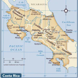
> Costa Rica
> Maps
> North America
> Costa Rica
> Related Images
> North America
> Honduras
> Maps
> North America
> Honduras
> Related Images
> North America
> Mexico
> Maps
> North America
> Mexico
> Related Images
> North America
> Nicaragua
> Maps
> North America
> Nicaragua
> Related Images
EDITORS COMMENTS
This stunning geography map print from the early 18th century showcases a detailed representation of Central America, including Mexico, Yucatan, Honduras, Nicaragua, Costa Rica, and Florida. The West Indies are also prominently featured in this intricate engraving by Pierre Mortier.
The map offers a glimpse into the geographical layout of the region during that time period, providing valuable insight into the boundaries and topography of these areas. From the lush landscapes of Central America to the sprawling coastlines of North and South America, every detail is meticulously captured in this historical piece.
As you study this map closely, you can't help but marvel at the craftsmanship and attention to detail that went into creating such a precise depiction of these lands. Each line and curve tells a story of exploration and discovery in an era when cartography was still evolving as a science.
Whether you're a history buff or simply appreciate fine art, this geography map print is sure to captivate your imagination and transport you back to a time when maps were not just tools for navigation but works of art in their own right. Explore the world through the eyes of Pierre Mortier with this exquisite piece from Biblioteca Angelica in Rome.
MADE IN AUSTRALIA
Safe Shipping with 30 Day Money Back Guarantee
FREE PERSONALISATION*
We are proud to offer a range of customisation features including Personalised Captions, Color Filters and Picture Zoom Tools
SECURE PAYMENTS
We happily accept a wide range of payment options so you can pay for the things you need in the way that is most convenient for you
* Options may vary by product and licensing agreement. Zoomed Pictures can be adjusted in the Cart.