Home > Arts > Artists > B > Emanuel Bowen
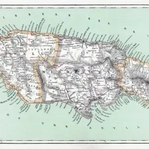
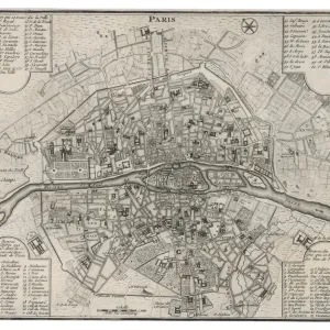
Map of the Island of Jamaica, divided into its Principal Parishes c. 1760 (hand-coloured engraving)
")
![]()
Wall Art and Photo Gifts from Fine Art Finder
Map of the Island of Jamaica, divided into its Principal Parishes c. 1760 (hand-coloured engraving)
BAL42817 Map of the Island of Jamaica, divided into its Principal Parishes c.1760 (hand-coloured engraving) by Bowen, Emanuel (c.1694-1767); O Shea Gallery, London, UK
Media ID 25130812
© Bridgeman Images
Atlas Caribbean Caribbean Island Carribean Cartography Detailed Geographical Labelled Outline Mythological Character Mythological Figure Myths Pagan Paganism Pagans Polytheism Polytheist
FEATURES IN THESE COLLECTIONS
> Arts
> Artists
> B
> Emanuel Bowen
> Arts
> Photorealistic artworks
> Detailed art pieces
> Masterful detailing in art
> Europe
> United Kingdom
> Maps
> Fine Art Finder
> Artists
> Emanuel Bowen
> Fine Art Finder
> Artists
> Otto Freundlich
> Fine Art Finder
> Maps (celestial & Terrestrial)
> Maps and Charts
> Early Maps
> North America
> Jamaica
> Maps
> North America
> Jamaica
> Related Images
EDITORS COMMENTS
This hand-coloured engraving, titled "Map of the Island of Jamaica, divided into its Principal Parishes c. 1760" takes us on a journey back to the 18th century Caribbean. Created by Emanuel Bowen, a renowned cartographer of his time, this detailed map showcases the geography and outline of the island with vibrant colors that bring it to life. As we explore this historical artifact, we are drawn not only to its geographical accuracy but also to an intriguing mythological figure depicted within its borders. A pagan deity stands tall amidst the parishes, reminding us of the rich religious beliefs and polytheistic traditions prevalent in that era. This inclusion adds an extra layer of depth and curiosity to an already fascinating piece. The map's meticulous labeling allows us to navigate through each parish effortlessly while providing insight into their significance during that period. It serves as a valuable resource for historians and researchers seeking knowledge about early Jamaican settlements and landmarks. Through this engraving, we catch a glimpse of Jamaica's past - a time when myths intertwined with reality and religion played a significant role in shaping society. The combination of accurate cartography and mythical symbolism creates an artistic fusion that captivates our imagination. Displayed at London's O Shea Gallery, this print from Bridgeman Images is not just a visual masterpiece but also represents an important part of Caribbean history waiting to be explored by those who appreciate both artistry and historical context.
MADE IN AUSTRALIA
Safe Shipping with 30 Day Money Back Guarantee
FREE PERSONALISATION*
We are proud to offer a range of customisation features including Personalised Captions, Color Filters and Picture Zoom Tools
SECURE PAYMENTS
We happily accept a wide range of payment options so you can pay for the things you need in the way that is most convenient for you
* Options may vary by product and licensing agreement. Zoomed Pictures can be adjusted in the Cart.