Home > Africa > Morocco > Maps
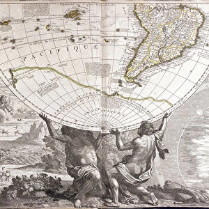
Geographic map of the empire of Morocco in 859. Engraving in "

![]()
Wall Art and Photo Gifts from Fine Art Finder
Geographic map of the empire of Morocco in 859. Engraving in "
XEE4143802 Geographic map of the empire of Morocco in 859. Engraving in " Le Monde Illustre" nA'129 of 1 October 1859. by French School, (19th century); Private Collection; (add.info.: Geographic map of the empire of Morocco in 859. Engraving in " Le Monde Illustre" nA'129 of 1 October 1859.); Stefano Bianchetti; French, out of copyright
Media ID 23707900
© Stefano Bianchetti / Bridgeman Images
Geographical Map Moroccan Morocco
FEATURES IN THESE COLLECTIONS
> Africa
> Morocco
> Related Images
> Arts
> Artists
> Related Images
> Fine Art Finder
> Artists
> French School
> Fine Art Finder
> Artists
> Unknown Artist
> Maps and Charts
> Related Images
EDITORS COMMENTS
This print showcases a historical geographic map of the empire of Morocco in 859. The intricate engraving, featured in "Le Monde Illustre" nA'129 on 1 October 1859, was created by the talented French School from the 19th century. This remarkable piece is part of a private collection and offers an invaluable glimpse into Moroccan history. The detailed map highlights the vast expanse of North Africa's empire during this period, providing insight into its geographical boundaries and territories. It serves as a testament to Morocco's rich cultural heritage and its significant role in African history. The artist behind this masterpiece, Stefano Bianchetti, skillfully captures every intricate detail with precision and accuracy. Through his work, he transports us back in time to an era when cartography played a vital role in understanding our world. As we explore this enchanting engraving, we are reminded of the importance of preserving historical artifacts like these. They serve as windows into our past, allowing us to appreciate the achievements and complexities that shaped civilizations long ago. Whether you have a passion for geography or simply admire fine art prints that tell stories through their imagery, this stunning depiction of Morocco's empire is sure to captivate your imagination.
MADE IN AUSTRALIA
Safe Shipping with 30 Day Money Back Guarantee
FREE PERSONALISATION*
We are proud to offer a range of customisation features including Personalised Captions, Color Filters and Picture Zoom Tools
FREE COLORIZATION SERVICE
You can choose advanced AI Colorization for this picture at no extra charge!
SECURE PAYMENTS
We happily accept a wide range of payment options so you can pay for the things you need in the way that is most convenient for you
* Options may vary by product and licensing agreement. Zoomed Pictures can be adjusted in the Cart.