Home > Maps and Charts > Americas
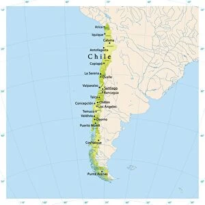
Geography map: representation of the coasts of Chile, made by Dutch cartographer Gerard van Keulen (1678-1726) 1709-1713. Biblioteca Angelica, Rome
 1709-1713. Biblioteca Angelica, Rome")
![]()
Wall Art and Photo Gifts from Fine Art Finder
Geography map: representation of the coasts of Chile, made by Dutch cartographer Gerard van Keulen (1678-1726) 1709-1713. Biblioteca Angelica, Rome
VEN5030133 Geography map: representation of the coasts of Chile, made by Dutch cartographer Gerard van Keulen (1678-1726) 1709-1713. Biblioteca Angelica, Rome; (add.info.: Geography map: representation of the coasts of Chile, made by Dutch cartographer Gerard van Keulen (1678-1726) 1709-1713. Biblioteca Angelica, Rome); © Marage Photos
Media ID 38167636
© © Marage Photos / Bridgeman Images
18eme Siecle Amerique (continent) Amerique Du Nord Amerique Du Sud Carte Geographique Chile Chilean Chili Chilian Chilians Etats Unis Geographical Map Geographie Latin America Latinamerica Latine America Republic Of Chile Southamerica Stockravenna
FEATURES IN THESE COLLECTIONS
> Fine Art Finder
> Artists
> Unknown Artist
> Maps and Charts
> Early Maps
> North America
> United States of America
> Maps
> South America
> Chile
> Maps
> South America
> Chile
> Related Images
EDITORS COMMENTS
This stunning geography map, depicting the coasts of Chile, is a masterpiece created by Dutch cartographer Gerard van Keulen between 1709 and 1713. The intricate details and accuracy of this map showcase the skill and expertise of van Keulen in capturing the geographical features of this South American country.
The representation of Chile's coastline on this map provides a valuable historical insight into the region during the early 18th century. From its northern border with Peru to its southern tip near Antarctica, every detail is meticulously recorded for future generations to study and appreciate.
Housed in the Biblioteca Angelica in Rome, this rare print offers a glimpse into the past when exploration and cartography were at their peak. The blend of artistry and scientific precision in creating such maps reflects a time when knowledge was highly valued and sought after.
As we admire this piece today, we are reminded of the importance of preserving our history through visual representations like these. Van Keulen's work serves as a testament to human curiosity and ingenuity in understanding our world, making it an invaluable addition to any collection or educational institution.
MADE IN AUSTRALIA
Safe Shipping with 30 Day Money Back Guarantee
FREE PERSONALISATION*
We are proud to offer a range of customisation features including Personalised Captions, Color Filters and Picture Zoom Tools
SECURE PAYMENTS
We happily accept a wide range of payment options so you can pay for the things you need in the way that is most convenient for you
* Options may vary by product and licensing agreement. Zoomed Pictures can be adjusted in the Cart.