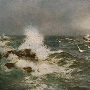
Home > Arts > Watercolor paintings > Seascape watercolor paintings > Ocean landscapes
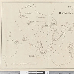
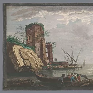
Page 25b / a Map and profile of Palmerston Island, 1768-75 (pen & ink and w / c)
")
![]()
Wall Art and Photo Gifts from Fine Art Finder
Page 25b / a Map and profile of Palmerston Island, 1768-75 (pen & ink and w / c)
5670283 Page 25b/a Map and profile of Palmerston Island, 1768-75 (pen & ink and w/c) by Hodges, William (1744-97); Mitchell Library, State Library of New South Wales; (add.info.: Original Sketches, Drawings, Maps etc Collected by Admiral Isaac Smith / drawings and watercolours, mainly of Captain Cooks Second Voyage (1772-1775) by William Hodges, Henry Roberts etc
Dimensions: Album measures 49 x 70 cm); Mitchell Library, State Library of New South Wales; English, out of copyright
Media ID 22795146
© Mitchell Library, State Library of New South Wales / Bridgeman Images
Cartographic Cartography Chart Cooks Second Voyage Elevation Expedition Flat Geographical Hydrographic Hydrography Islands Isolated Land Mapping Pacific Ocean Second Voyage Of Captain Cook South Pacific Survey Surveying Cook Islands Coral Atoll
FEATURES IN THESE COLLECTIONS
> Arts
> Art Movements
> Seascapes
> Arts
> Artists
> H
> William Hodges
> Arts
> Landscape paintings
> Coastal landscapes
> Seascape art
> Arts
> Still life artwork
> Watercolor paintings
> Fine art
> Arts
> Watercolor paintings
> Seascape watercolor paintings
> Coastal scenes
> Arts
> Watercolor paintings
> Seascape watercolor paintings
> Ocean landscapes
> Europe
> United Kingdom
> Wales
> Maps
> Europe
> United Kingdom
> Wales
> Paintings
> Fine Art Finder
> Artists
> William Hodges
> Maps and Charts
> Wales
EDITORS COMMENTS
Page 25b / a Map and profile of Palmerston Island, 1768-75 (pen & ink and w/c) by William Hodges captures the essence of exploration in the 18th century. This remarkable print, housed at the Mitchell Library, State Library of New South Wales, showcases original sketches, drawings, maps collected by Admiral Isaac Smith. The intricately detailed drawing combines cartography with artistry to depict the coastline and shoreline of Palmerston Island. The artist's use of pen and ink alongside watercolors brings depth and life to this historical map. With its isolated location in the Pacific Ocean, this coral atoll was part of Captain Cook's second voyage (1772-1775), making it an important piece for understanding early exploration. The map not only provides geographical information but also offers a glimpse into the challenges faced by explorers during that time. It highlights elevation changes along with flat profiles, showcasing land formations on this remote island. The chart serves as a valuable resource for surveying and mapping purposes. As we admire this painting from the xviiith century, we are transported back in time to witness Captain Cook's expedition through Hodges' skilled brushstrokes. The sea surrounding Palmerston Island is beautifully depicted with shades of blue that evoke a sense of tranquility amidst maritime adventures. This artwork invites us to appreciate both its artistic beauty and historical significance as it sheds light on early exploration efforts in Oceania.
MADE IN AUSTRALIA
Safe Shipping with 30 Day Money Back Guarantee
FREE PERSONALISATION*
We are proud to offer a range of customisation features including Personalised Captions, Color Filters and Picture Zoom Tools
SECURE PAYMENTS
We happily accept a wide range of payment options so you can pay for the things you need in the way that is most convenient for you
* Options may vary by product and licensing agreement. Zoomed Pictures can be adjusted in the Cart.