Fine Art Print > Asia > India > Maps
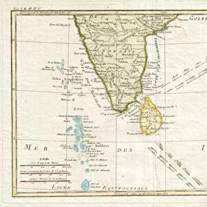
Fine Art Print : Map Of Southern India, Circa. 1760. From "Atlas De Toutes Les Parties Connues Du Globe Terrestre "By Cartographer Rigobert Bonne. Published Geneva Circa. 1760


![]()
Fine Art Prints from Design Pics
Map Of Southern India, Circa. 1760. From "Atlas De Toutes Les Parties Connues Du Globe Terrestre "By Cartographer Rigobert Bonne. Published Geneva Circa. 1760
Map Of Southern India, Circa.1760. From " Atlas De Toutes Les Parties Connues Du Globe Terrestre " By Cartographer Rigobert Bonne. Published Geneva Circa. 1760
Design Pics offers Distinctively Different Imagery representing over 1,500 contributors
Media ID 18186443
© Ken Welsh / Design Pics
Cartography Geography India Mapmaking Plate Southern
21"x14" (+3" Border) Fine Art Print
Step back in time with our exquisite Fine Art Print of a Map of Southern India from the "Atlas De Toutes Les Parties Connues Du Globe Terrestre," published in Geneva around 1760. This stunning vintage map is an authentic reproduction of the original work by renowned cartographer Rigobert Bonne. The intricate details and vibrant colors of this map transport you back to the 18th century, making it a captivating addition to any home or office. Decorate your walls with history and bring a touch of the past into your modern space. Order now and experience the rich heritage of cartography.
21x14 image printed on 27x20 Fine Art Rag Paper with 3" (76mm) white border. Our Fine Art Prints are printed on 300gsm 100% acid free, PH neutral paper with archival properties. This printing method is used by museums and art collections to exhibit photographs and art reproductions.
Our fine art prints are high-quality prints made using a paper called Photo Rag. This 100% cotton rag fibre paper is known for its exceptional image sharpness, rich colors, and high level of detail, making it a popular choice for professional photographers and artists. Photo rag paper is our clear recommendation for a fine art paper print. If you can afford to spend more on a higher quality paper, then Photo Rag is our clear recommendation for a fine art paper print.
Estimated Image Size (if not cropped) is 53.3cm x 35.5cm (21" x 14")
Estimated Product Size is 68.6cm x 50.8cm (27" x 20")
These are individually made so all sizes are approximate
Artwork printed orientated as per the preview above, with landscape (horizontal) orientation to match the source image.
FEATURES IN THESE COLLECTIONS
> Asia
> India
> Related Images
> Maps and Charts
> India
EDITORS COMMENTS
This print showcases a beautifully detailed map of Southern India, circa 1760. Taken from the renowned "Atlas De Toutes Les Parties Connues Du Globe Terrestre" by cartographer Rigobert Bonne and published in Geneva around the same time, this piece is a true testament to the artistry and precision of historical mapmaking. The vibrant colors and intricate engravings bring this map to life, allowing us to explore the geography of Southern India as it was understood over two centuries ago. From its horizontal layout to its carefully crafted illustrations, every aspect of this print demonstrates the skill and dedication that went into creating such an invaluable resource. As we gaze upon this remarkable work, we are transported back in time, gaining insight into how our understanding of the world has evolved. It serves as a reminder of both our shared history and the importance of preserving these artifacts for future generations. Ken Welsh's expert reproduction captures every nuance and detail with utmost accuracy, ensuring that this piece remains accessible for all who appreciate its beauty. Whether you're an enthusiast of cartography or simply drawn to colorful illustrations, this print is sure to captivate your imagination and spark curiosity about Southern India's rich cultural heritage.
MADE IN AUSTRALIA
Safe Shipping with 30 Day Money Back Guarantee
FREE PERSONALISATION*
We are proud to offer a range of customisation features including Personalised Captions, Color Filters and Picture Zoom Tools
SECURE PAYMENTS
We happily accept a wide range of payment options so you can pay for the things you need in the way that is most convenient for you
* Options may vary by product and licensing agreement. Zoomed Pictures can be adjusted in the Cart.