Fine Art Print > Europe > France > Canton > Orne
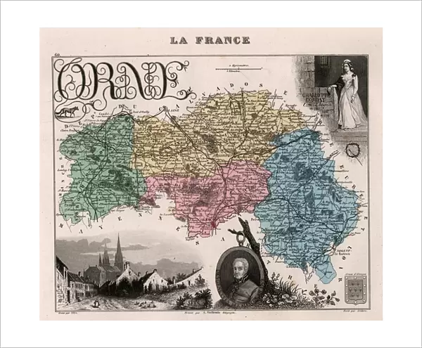
Fine Art Print : L Orne (61), Lower Normandy (Lower Normandy) - France and its Colonies. Atlas illustrates one hundred and five maps from the maps of the depot of war, bridges and footwear and the Navy by M. VUILLEMIN. 1876
, Lower Normandy (Lower Normandy) - France and its Colonies. Atlas illustrates one hundred and five maps from the maps of the depot of war, bridges and footwear and the Navy by M. VUILLEMIN. 1876")

![]()
Fine Art Prints from Fine Art Finder
L Orne (61), Lower Normandy (Lower Normandy) - France and its Colonies. Atlas illustrates one hundred and five maps from the maps of the depot of war, bridges and footwear and the Navy by M. VUILLEMIN. 1876
XEE4144481 L Orne (61), Lower Normandy (Lower Normandy) - France and its Colonies. Atlas illustrates one hundred and five maps from the maps of the depot of war, bridges and footwear and the Navy by M. VUILLEMIN. 1876. by Vuillemin, Alexandre (1812-1886); Private Collection; (add.info.: L Orne (61), Lower Normandy (Lower Normandy) - France and its Colonies. Atlas illustrates one hundred and five maps from the maps of the depot of war, bridges and footwear and the Navy by M. VUILLEMIN. 1876.); Stefano Bianchetti; French, out of copyright
Media ID 25163950
© Stefano Bianchetti / Bridgeman Images
Atlas Book Lower Normandy Lower Normandy Orne 61 Geographical Map
20"x16" (+3" Border) Fine Art Print
Discover the rich history and geography of Lower Normandy, France, and its colonies with this exquisite Fine Art Print from Media Storehouse. Originally published in 1876, this atlas, titled "L Orne (61), Lower Normandy (Lower Normandy) - France and its Colonies," features one hundred and five meticulously detailed maps. Each map was originally created by M. VUILLEMIN for the depots of war, bridges, and footwear, and the Navy. This captivating print, copyrighted by Stefano Bianchetti from Fine Art Finder, is an essential addition to any history or cartography enthusiast's collection. Immerse yourself in the intricacies of the past, and bring a piece of historical cartography into your home or office.
20x16 image printed on 26x22 Fine Art Rag Paper with 3" (76mm) white border. Our Fine Art Prints are printed on 300gsm 100% acid free, PH neutral paper with archival properties. This printing method is used by museums and art collections to exhibit photographs and art reproductions.
Our fine art prints are high-quality prints made using a paper called Photo Rag. This 100% cotton rag fibre paper is known for its exceptional image sharpness, rich colors, and high level of detail, making it a popular choice for professional photographers and artists. Photo rag paper is our clear recommendation for a fine art paper print. If you can afford to spend more on a higher quality paper, then Photo Rag is our clear recommendation for a fine art paper print.
Estimated Image Size (if not cropped) is 47.5cm x 40.6cm (18.7" x 16")
Estimated Product Size is 66cm x 55.9cm (26" x 22")
These are individually made so all sizes are approximate
Artwork printed orientated as per the preview above, with landscape (horizontal) orientation to match the source image.
FEATURES IN THESE COLLECTIONS
> Fine Art Finder
> Artists
> Alexandre Vuillemin
> Europe
> France
> Canton
> Orne
> Maps and Charts
> Related Images
> Services
> Royal Navy
EDITORS COMMENTS
This print showcases a stunning geographical map of L'Orne, located in Lower Normandy, France. The map is part of an atlas that features one hundred and five meticulously detailed maps from various sources such as the depot of war, bridges and footwear, and the Navy by M. Vuillemin. Created in 1876 by Alexandre Vuillemin (1812-1886), this historical piece offers a glimpse into the rich cartographic heritage of France. The intricate engravings beautifully depict the topography and landmarks of L'Orne, providing valuable insights into its geography during that era. The vibrant colors used to bring this map to life add depth and visual appeal to the artwork. This particular print is part of a private collection owned by Stefano Bianchetti. It serves as a testament to his passion for preserving historical artifacts like this remarkable atlas book. Whether you are an avid collector or simply fascinated by French geography, this print transports you back in time to explore the landscapes and territories that once shaped Lower Normandy's history. Its exquisite details make it a truly remarkable addition to any art collection or educational resource on French culture and history.
MADE IN AUSTRALIA
Safe Shipping with 30 Day Money Back Guarantee
FREE PERSONALISATION*
We are proud to offer a range of customisation features including Personalised Captions, Color Filters and Picture Zoom Tools
SECURE PAYMENTS
We happily accept a wide range of payment options so you can pay for the things you need in the way that is most convenient for you
* Options may vary by product and licensing agreement. Zoomed Pictures can be adjusted in the Cart.