Fine Art Print > Europe > France > Canton > Loiret
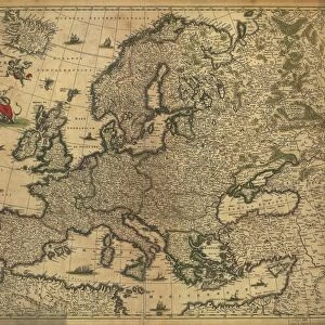
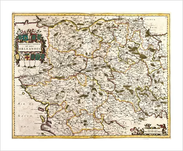
Fine Art Print : Map of the general government of the Orlean country (France) (etching, 1671)
 (etching, 1671)")

![]()
Fine Art Prints from Fine Art Finder
Map of the general government of the Orlean country (France) (etching, 1671)
LRI4709751 Map of the general government of the Orlean country (France) (etching, 1671) by Wit, Frederick de (1630-1706); Private Collection; (add.info.: Map of the general government of the Orlean country (France) - Strong water extracted from " Theatrum Orbis", 1671, by Frederick De Wit (Frederico de Witt) (1630-1706)); Luisa Ricciarini; Dutch, out of copyright
Media ID 23734626
© Luisa Ricciarini / Bridgeman Images
Atlas Book Center Loiret 45 Geographical Map
20"x16" (+3" Border) Fine Art Print
Discover the intricacies of 17th-century French political geography with our exquisite etching from the Media Storehouse Fine Art Prints collection. This rare and captivating work, titled "Map of the general government of the Orlean country (France)" by Wit, Frederick de, dates back to 1671. Etched by the talented Luisa Ricciarini, this piece offers a fascinating glimpse into the historical cartography of the time. With its intricate details and beautiful lines, this print is not just a map, but a work of art that tells a story of its own. Add this masterpiece to your collection and bring a touch of history into your home or office.
20x16 image printed on 26x22 Fine Art Rag Paper with 3" (76mm) white border. Our Fine Art Prints are printed on 300gsm 100% acid free, PH neutral paper with archival properties. This printing method is used by museums and art collections to exhibit photographs and art reproductions.
Our fine art prints are high-quality prints made using a paper called Photo Rag. This 100% cotton rag fibre paper is known for its exceptional image sharpness, rich colors, and high level of detail, making it a popular choice for professional photographers and artists. Photo rag paper is our clear recommendation for a fine art paper print. If you can afford to spend more on a higher quality paper, then Photo Rag is our clear recommendation for a fine art paper print.
Estimated Image Size (if not cropped) is 50.8cm x 40.6cm (20" x 16")
Estimated Product Size is 66cm x 55.9cm (26" x 22")
These are individually made so all sizes are approximate
Artwork printed orientated as per the preview above, with landscape (horizontal) orientation to match the source image.
FEATURES IN THESE COLLECTIONS
> Fine Art Finder
> Artists
> Frederick de Wit
> Animals
> Mammals
> Muridae
> Water Mouse
> Arts
> Artists
> W
> Frederick de Wit
> Europe
> France
> Canton
> Loiret
> Maps and Charts
> Related Images
EDITORS COMMENTS
This print showcases a remarkable piece of cartographic history - the "Map of the general government of the Orlean country (France)" created by Frederick de Wit in 1671. With intricate etching techniques, De Wit masterfully crafted this map as part of his renowned work "Theatrum Orbis" offering a glimpse into the geographical landscape of France during that era. The map itself is a testament to De Wit's expertise and attention to detail, capturing the essence of the Orlean region with precision. It provides an invaluable resource for historians and geographers alike, shedding light on the political divisions and administrative boundaries that shaped France at that time. Luisa Ricciarini has skillfully captured this historical gem through her lens, preserving its beauty for generations to come. The center placement emphasizes its significance within art history while highlighting its importance as an engraving and geographical map. As we delve into this image, we are transported back in time, immersing ourselves in seventeenth-century France. We can almost envision explorers using maps like these to navigate their way through unfamiliar territories or scholars studying them meticulously for academic purposes. This print serves as a visual reminder of how art can transcend time and bring us closer to understanding our past. It stands as a tribute not only to De Wit's craftsmanship but also to Ricciarini's talent in capturing such historical treasures through her lens.
MADE IN AUSTRALIA
Safe Shipping with 30 Day Money Back Guarantee
FREE PERSONALISATION*
We are proud to offer a range of customisation features including Personalised Captions, Color Filters and Picture Zoom Tools
SECURE PAYMENTS
We happily accept a wide range of payment options so you can pay for the things you need in the way that is most convenient for you
* Options may vary by product and licensing agreement. Zoomed Pictures can be adjusted in the Cart.