Fine Art Print > Europe > United Kingdom > England > London > Sights > British Museum
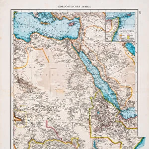
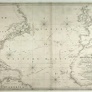
Fine Art Print : A Chart of the Atlantic or Western Ocean, showing the track of Nelsons fleet


![]()
Fine Art Prints from Fine Art Finder
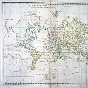
A Chart of the Atlantic or Western Ocean, showing the track of Nelsons fleet
3244750 A Chart of the Atlantic or Western Ocean, showing the track of Nelsons fleet, 12th May-15th August 1805, 1807 (engraving) by Faden, William (1750-1836); National Museum of the Royal Navy, Portsmouth, Hampshire, UK; (add.info.: Engraved chart showing the track of Nelsons fleet, 12th May-15th August 1805. Published by W. Faden, Geographer to His Majesty, Charing Cross 12th August 1807 and approved by the Admiralty Chart Committee. Noted as copied from his Lordships original manuscript, under his Lordships special directions.); eNational Museum of the Royal Navy; British, out of copyright
Media ID 22438772
© National Museum of the Royal Navy / Bridgeman Images
Admiral Nelson Atlantic Ocean Continents Mapping Tracking
21"x14" (+3" Border) Fine Art Print
Discover the rich maritime history brought to life with this stunning Fine Art Print from Media Storehouse. Featuring an engraving by William Faden from 1807, this Chart of the Atlantic or Western Ocean showcases the track of Nelson's fleet from May 12th to August 15th, 1805. A captivating addition to any home or office, this fine art print transports you back in time, offering a glimpse into the epic naval journey of one of history's most legendary figures. Bring the past to the present with this exquisite piece from Fine Art Finder by Bridgeman Images.
21x14 image printed on 27x20 Fine Art Rag Paper with 3" (76mm) white border. Our Fine Art Prints are printed on 300gsm 100% acid free, PH neutral paper with archival properties. This printing method is used by museums and art collections to exhibit photographs and art reproductions.
Our fine art prints are high-quality prints made using a paper called Photo Rag. This 100% cotton rag fibre paper is known for its exceptional image sharpness, rich colors, and high level of detail, making it a popular choice for professional photographers and artists. Photo rag paper is our clear recommendation for a fine art paper print. If you can afford to spend more on a higher quality paper, then Photo Rag is our clear recommendation for a fine art paper print.
Estimated Image Size (if not cropped) is 53.3cm x 35.5cm (21" x 14")
Estimated Product Size is 68.6cm x 50.8cm (27" x 20")
These are individually made so all sizes are approximate
Artwork printed orientated as per the preview above, with landscape (horizontal) orientation to match the source image.
FEATURES IN THESE COLLECTIONS
> Fine Art Finder
> Artists
> Thomas (after) Rowlandson
> Fine Art Finder
> Artists
> William Faden
> Fine Art Finder
> Maps (celestial & Terrestrial)
> Africa
> South Africa
> Maps
> Africa
> South Africa
> Related Images
> Arts
> Artists
> F
> William Faden
> Arts
> Artists
> O
> Oceanic Oceanic
> Europe
> United Kingdom
> England
> Hampshire
> Fleet
> Europe
> United Kingdom
> England
> Hampshire
> Portsmouth
> Europe
> United Kingdom
> England
> Hampshire
> Related Images
> Europe
> United Kingdom
> England
> London
> Sights
> British Museum
EDITORS COMMENTS
This engraving, titled "A Chart of the Atlantic or Western Ocean, showing the track of Nelson's fleet" takes us back to a significant moment in history. Created by William Faden and displayed at the National Museum of the Royal Navy in Portsmouth, UK, this artwork provides a visual representation of Admiral Nelson's fleet's journey from 12th May to 15th August 1805. The intricate details on this naval map offer a glimpse into the strategic movements and routes taken by Nelson's fleet during that crucial period. Published under Faden's expertise as Geographer to His Majesty and approved by the Admiralty Chart Committee, it holds immense historical value. Notably copied from Lord Nelson's original manuscript with his special directions, this chart showcases Europe, North America, South America, and Africa along with their surrounding waters. It serves as an essential tool for understanding how naval forces navigated through vast oceans during that era. As we observe this remarkable piece of artistry and cartography combined, we are reminded of Admiral Horatio Nelson's exceptional leadership skills and his pivotal role in shaping British naval history. This print not only captures a specific moment but also symbolizes courage and determination exhibited by those who sailed these treacherous waters centuries ago.
MADE IN AUSTRALIA
Safe Shipping with 30 Day Money Back Guarantee
FREE PERSONALISATION*
We are proud to offer a range of customisation features including Personalised Captions, Color Filters and Picture Zoom Tools
SECURE PAYMENTS
We happily accept a wide range of payment options so you can pay for the things you need in the way that is most convenient for you
* Options may vary by product and licensing agreement. Zoomed Pictures can be adjusted in the Cart.