Fine Art Print > North America > United States of America > New York > New York > Maps
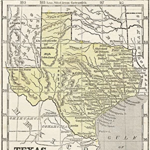
Fine Art Print : Texas map 1881


![]()
Fine Art Prints from Fine Art Storehouse
Texas map 1881
Coltons Common School Geography 1881 New York Sheldon and Co
Unleash your creativity and transform your space into a visual masterpiece!
THEPALMER
Media ID 13669267
© This content is subject to copyright
American Culture Globe Navigational Equipment Gulf Coast States North America Paper Planet Earth Texas World Map
20"x16" (+3" Border) Fine Art Print
Step back in time with our exquisite Texas map print from ThePalmer, available at Fine Art Storehouse. This captivating piece, originally published in 1881 by Colton's Common School Geography from Sheldon and Co, New York, showcases an intriguing and historically significant representation of the Lone Star State. Add a touch of vintage charm to your space, and transport yourself on a journey through Texas' rich history. Each print is meticulously produced using premium materials and techniques, ensuring a stunning and long-lasting addition to your home or office decor.
20x16 image printed on 26x22 Fine Art Rag Paper with 3" (76mm) white border. Our Fine Art Prints are printed on 300gsm 100% acid free, PH neutral paper with archival properties. This printing method is used by museums and art collections to exhibit photographs and art reproductions.
Our fine art prints are high-quality prints made using a paper called Photo Rag. This 100% cotton rag fibre paper is known for its exceptional image sharpness, rich colors, and high level of detail, making it a popular choice for professional photographers and artists. Photo rag paper is our clear recommendation for a fine art paper print. If you can afford to spend more on a higher quality paper, then Photo Rag is our clear recommendation for a fine art paper print.
Estimated Image Size (if not cropped) is 40.6cm x 48.3cm (16" x 19")
Estimated Product Size is 55.9cm x 66cm (22" x 26")
These are individually made so all sizes are approximate
Artwork printed orientated as per the preview above, with portrait (vertical) orientation to match the source image.
FEATURES IN THESE COLLECTIONS
> Maps and Charts
> Related Images
> Maps and Charts
> World
> North America
> Related Images
> North America
> United States of America
> Maps
> North America
> United States of America
> New York
> New York
> Maps
> North America
> United States of America
> New York
> Related Images
> North America
> United States of America
> Texas
> Related Images
> Science
> Space Exploration
> Planets
> Earth
> Fine Art Storehouse
> The Magical World of Illustration
> Palmer Illustrated Collection
> Fine Art Storehouse
> Map
> Historical Maps
> Fine Art Storehouse
> Map
> USA Maps
EDITORS COMMENTS
In this print titled "Texas map 1881" we are transported back in time to the late 19th century, when cartography was a meticulous art form. The image showcases an exquisite engraving from Colton's Common School Geography of 1881, published by Sheldon and Co in New York. This vintage piece offers us a glimpse into the past, revealing the intricate details of Texas' geography as it existed over a century ago. The map itself is beautifully crafted, showcasing not only Texas but also its surrounding Gulf Coast states within North America. Its vertical orientation allows us to appreciate the vastness and diversity of this great state. As we examine closer, we can see how early navigational equipment like globes were incorporated into the design, emphasizing both exploration and education. This antique illustration transports us to an era where paper maps were essential tools for understanding our world. It serves as a reminder of American culture's deep-rooted connection with physical geography and exploration. "The Texas map 1881" by THEPALMER takes us on a journey through time while celebrating the artistry behind old-world cartography. It invites viewers to reflect on how our perception of planet Earth has evolved throughout history while appreciating the beauty found within engraved images such as this one.
MADE IN AUSTRALIA
Safe Shipping with 30 Day Money Back Guarantee
FREE PERSONALISATION*
We are proud to offer a range of customisation features including Personalised Captions, Color Filters and Picture Zoom Tools
SECURE PAYMENTS
We happily accept a wide range of payment options so you can pay for the things you need in the way that is most convenient for you
* Options may vary by product and licensing agreement. Zoomed Pictures can be adjusted in the Cart.