Fine Art Print > North America > United States of America > New York > New York > Maps
Fine Art Print : United States map 1875


![]()
Fine Art Prints from Fine Art Storehouse
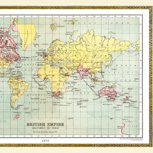
United States map 1875
The Independent Course Comprehensive Geography by James Monteith, A.S. Barnes & Co, New York & Chicago 1875
Unleash your creativity and transform your space into a visual masterpiece!
THEPALMER
Media ID 13612201
© This content is subject to copyright
Globe Navigational Equipment North America Paper United States
21"x14" (+3" Border) Fine Art Print
Step back in time with this exquisite fine art print from the Media Storehouse collection. Featuring an intricately detailed United States map from 1875, created by THEPALMER for The Independent Course in Comprehensive Geography by James Monteith. This vintage map transports you to a bygone era, with carefully hand-drawn borders, topography, and place names. Bring history into your home or office with this beautiful and authentic piece of cartographic art.
21x14 image printed on 27x20 Fine Art Rag Paper with 3" (76mm) white border. Our Fine Art Prints are printed on 300gsm 100% acid free, PH neutral paper with archival properties. This printing method is used by museums and art collections to exhibit photographs and art reproductions.
Our fine art prints are high-quality prints made using a paper called Photo Rag. This 100% cotton rag fibre paper is known for its exceptional image sharpness, rich colors, and high level of detail, making it a popular choice for professional photographers and artists. Photo rag paper is our clear recommendation for a fine art paper print. If you can afford to spend more on a higher quality paper, then Photo Rag is our clear recommendation for a fine art paper print.
Estimated Image Size (if not cropped) is 53.3cm x 30.1cm (21" x 11.9")
Estimated Product Size is 68.6cm x 50.8cm (27" x 20")
These are individually made so all sizes are approximate
Artwork printed orientated as per the preview above, with landscape (horizontal) orientation to match the source image.
FEATURES IN THESE COLLECTIONS
> Maps and Charts
> Related Images
> North America
> Related Images
> North America
> United States of America
> Maps
> North America
> United States of America
> New York
> New York
> Maps
> North America
> United States of America
> New York
> Related Images
> Fine Art Storehouse
> The Magical World of Illustration
> Palmer Illustrated Collection
> Fine Art Storehouse
> Map
> Historical Maps
> Fine Art Storehouse
> Map
> USA Maps
EDITORS COMMENTS
This print showcases a historical gem, the United States map of 1875. A relic from James Monteith's renowned book "The Independent Course Comprehensive Geography" this exquisite piece was published by A. S. Barnes & Co in New York and Chicago during that era. The map itself is a testament to the artistry and precision of cartography, beautifully engraved on old paper with intricate details. Transporting us back in time, this horizontal image captures the vastness of North America, specifically focusing on the United States. It serves as a visual representation of how our nation once appeared, offering insight into its physical geography and navigational routes across land and sea. The antique charm emanating from this engraving is undeniable; it exudes an air of nostalgia that captivates any viewer. As we gaze upon this illustration, we are reminded not only of our country's rich history but also of the craftsmanship involved in creating such masterpieces before modern technology took over. "The Independent Course Comprehensive Geography" has left an indelible mark on educational literature, providing generations with invaluable knowledge about our world. This particular print curated by THEPALMER for Fine Art Storehouse allows us to appreciate both its artistic value and educational significance. Whether you're a history enthusiast or simply intrigued by vintage aesthetics, this remarkable print transports you to a different era while celebrating the beauty found within maps as works of art themselves.
MADE IN AUSTRALIA
Safe Shipping with 30 Day Money Back Guarantee
FREE PERSONALISATION*
We are proud to offer a range of customisation features including Personalised Captions, Color Filters and Picture Zoom Tools
SECURE PAYMENTS
We happily accept a wide range of payment options so you can pay for the things you need in the way that is most convenient for you
* Options may vary by product and licensing agreement. Zoomed Pictures can be adjusted in the Cart.