Photo Mug > North America > United States of America > New York > New York > Maps
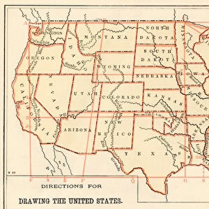
Photo Mug : United States map 1875


![]()
Home Decor from Fine Art Storehouse
United States map 1875
The Independent Course Comprehensive Geography by James Monteith, A.S. Barnes & Co, New York & Chicago 1875
Unleash your creativity and transform your space into a visual masterpiece!
THEPALMER
Media ID 13612201
© This content is subject to copyright
Globe Navigational Equipment North America Paper United States
Photo Mug
Add a touch of history to your morning routine with our Media Storehouse Photo Mug featuring a vintage United States map from 1875, taken from "The Independent Course in Geography" by James Monteith, published by A.S. Barnes & Co, New York & Chicago. This beautifully detailed map, showcased by THEPALMER from Fine Art Storehouse, is now transformed into a functional and stylish mug. Each mug holds a rich, full-color image that is heat-resistant and dishwasher safe, ensuring your map remains vibrant and clear. Start your day with a dose of history and a warm beverage in hand. Order yours today!
A personalised photo mug blends sentimentality with functionality, making an ideal gift for cherished loved ones, close friends, or valued colleagues. Preview may show both sides of the same mug.
Elevate your coffee or tea experience with our premium white ceramic mug. Its wide, comfortable handle makes drinking easy, and you can rely on it to be both microwave and dishwasher safe. Sold in single units, preview may show both sides of the same mug so you can see how the picture wraps around.
Mug Size is 8.1cm high x 9.6cm diameter (3.2" x 3.8")
These are individually made so all sizes are approximate
FEATURES IN THESE COLLECTIONS
> Fine Art Storehouse
> The Magical World of Illustration
> Palmer Illustrated Collection
> Fine Art Storehouse
> Map
> Historical Maps
> Fine Art Storehouse
> Map
> USA Maps
> Maps and Charts
> Related Images
> North America
> Related Images
> North America
> United States of America
> Maps
> North America
> United States of America
> New York
> New York
> Maps
> North America
> United States of America
> New York
> Related Images
EDITORS COMMENTS
This print showcases a historical gem, the United States map of 1875. A relic from James Monteith's renowned book "The Independent Course Comprehensive Geography" this exquisite piece was published by A. S. Barnes & Co in New York and Chicago during that era. The map itself is a testament to the artistry and precision of cartography, beautifully engraved on old paper with intricate details. Transporting us back in time, this horizontal image captures the vastness of North America, specifically focusing on the United States. It serves as a visual representation of how our nation once appeared, offering insight into its physical geography and navigational routes across land and sea. The antique charm emanating from this engraving is undeniable; it exudes an air of nostalgia that captivates any viewer. As we gaze upon this illustration, we are reminded not only of our country's rich history but also of the craftsmanship involved in creating such masterpieces before modern technology took over. "The Independent Course Comprehensive Geography" has left an indelible mark on educational literature, providing generations with invaluable knowledge about our world. This particular print curated by THEPALMER for Fine Art Storehouse allows us to appreciate both its artistic value and educational significance. Whether you're a history enthusiast or simply intrigued by vintage aesthetics, this remarkable print transports you to a different era while celebrating the beauty found within maps as works of art themselves.
MADE IN AUSTRALIA
Safe Shipping with 30 Day Money Back Guarantee
FREE PERSONALISATION*
We are proud to offer a range of customisation features including Personalised Captions, Color Filters and Picture Zoom Tools
SECURE PAYMENTS
We happily accept a wide range of payment options so you can pay for the things you need in the way that is most convenient for you
* Options may vary by product and licensing agreement. Zoomed Pictures can be adjusted in the Cart.