Fine Art Print > Africa > Egypt > Maps
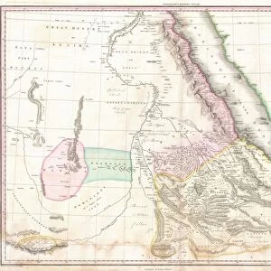
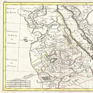
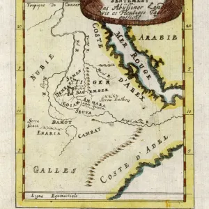
Fine Art Print : Antique map of Middle East with Arabia, Egypt, Nubia, and Abyssinia


![]()
Fine Art Prints from Fine Art Storehouse
Antique map of Middle East with Arabia, Egypt, Nubia, and Abyssinia
Unleash your creativity and transform your space into a visual masterpiece!
Hemera Technologies
Media ID 13609417
© Getty Images
Abyssinia Arabia Border Coordinates Direction Document Egypt Ethiopia Geography Horn Horn Of Africa Indian Ocean Israel Jordan Jordan Middle East Latitude Legend Libya Location Longitude Middle East Nile River Nubia Persian Gulf Place Positioning Red Sea Scale Sudan Lybia
20"x16" (+3" Border) Fine Art Print
Step back in time with our exquisite Antique Map of the Middle East from the Fine Art Storehouse by Hemera Technologies. This intricately detailed print transports you to a bygone era, featuring the historic regions of Arabia, Egypt, Nubia, and Abyssinia. With authentic cartography and vintage charm, this fine art print adds an air of sophistication and history to any space. Perfect for avid collectors, history enthusiasts, or those seeking to add a touch of timeless beauty to their home or office decor. Bring the past into the present with this stunning piece from the Fine Art Storehouse.
20x16 image printed on 26x22 Fine Art Rag Paper with 3" (76mm) white border. Our Fine Art Prints are printed on 300gsm 100% acid free, PH neutral paper with archival properties. This printing method is used by museums and art collections to exhibit photographs and art reproductions.
Our fine art prints are high-quality prints made using a paper called Photo Rag. This 100% cotton rag fibre paper is known for its exceptional image sharpness, rich colors, and high level of detail, making it a popular choice for professional photographers and artists. Photo rag paper is our clear recommendation for a fine art paper print. If you can afford to spend more on a higher quality paper, then Photo Rag is our clear recommendation for a fine art paper print.
Estimated Image Size (if not cropped) is 47.5cm x 40.6cm (18.7" x 16")
Estimated Product Size is 66cm x 55.9cm (26" x 22")
These are individually made so all sizes are approximate
Artwork printed orientated as per the preview above, with landscape (horizontal) orientation to match the source image.
FEATURES IN THESE COLLECTIONS
> Africa
> Egypt
> Related Images
> Africa
> Ethiopia (Abyssinia)
> Maps
> Africa
> Ethiopia (Abyssinia)
> Related Images
> Africa
> Ethiopia
> Related Images
> Africa
> Libya
> Related Images
> Africa
> Related Images
> Africa
> Sudan
> Related Images
> Fine Art Storehouse
> Map
> Historical Maps
EDITORS COMMENTS
This antique map of the Middle East takes us on a journey through time, unraveling the rich history and geography of this fascinating region. Printed by Hemera Technologies, it showcases Arabia, Egypt, Nubia, and Abyssinia in intricate detail. The map's archival quality transports us back to an era when cartography was both an art form and a scientific endeavor. Its delicate engravings depict borders, coordinates, and legends that guide our exploration. From the Persian Gulf to the Red Sea and from Israel to Sudan, every place is meticulously labeled with its longitude and latitude. As we trace the Nile River snaking through Egypt or follow the Horn of Africa jutting into the Indian Ocean, we are reminded of how physical geography has shaped civilizations over centuries. The absence of people in this image allows us to focus solely on nature's influence on human history. With its warm color palette and horizontal composition, this vintage print exudes a sense of nostalgia that invites contemplation. It serves as a reminder that understanding our past is essential for comprehending our present reality. Whether you are an avid historian or simply appreciate fine art photography, this antique map offers endless possibilities for discovery. Let it transport you across ancient lands while igniting your curiosity about cultures long gone but not forgotten.
MADE IN AUSTRALIA
Safe Shipping with 30 Day Money Back Guarantee
FREE PERSONALISATION*
We are proud to offer a range of customisation features including Personalised Captions, Color Filters and Picture Zoom Tools
SECURE PAYMENTS
We happily accept a wide range of payment options so you can pay for the things you need in the way that is most convenient for you
* Options may vary by product and licensing agreement. Zoomed Pictures can be adjusted in the Cart.