Fine Art Print > Fine Art Storehouse > Map
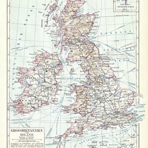
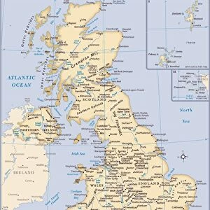
Fine Art Print : British isles map 1881


![]()
Fine Art Prints from Fine Art Storehouse
British isles map 1881
Harpers School Geography, New York, Harpers and Brothers, 1881
Unleash your creativity and transform your space into a visual masterpiece!
THEPALMER
Media ID 14756110
© This content is subject to copyright
Great Britain Ireland Scotland
20"x16" (+3" Border) Fine Art Print
Discover the captivating beauty of the past with our exquisite Fine Art Print of the British Isles Map from THEPALMER, published by Harpers and Brothers in New York in 1881. This intricately detailed map, taken from Harpers School Geography, transports you back in time to an era of exploration and discovery. The rich, vibrant colors and meticulous attention to detail bring the history of the British Isles to life, making this print an essential addition to any home or office. Perfect for history enthusiasts, cartography collectors, or those who appreciate the aesthetic charm of vintage maps, this Fine Art Print is a timeless treasure that tells a story of its own. Order yours today and let history unfold before your eyes.
20x16 image printed on 26x22 Fine Art Rag Paper with 3" (76mm) white border. Our Fine Art Prints are printed on 300gsm 100% acid free, PH neutral paper with archival properties. This printing method is used by museums and art collections to exhibit photographs and art reproductions.
Our fine art prints are high-quality prints made using a paper called Photo Rag. This 100% cotton rag fibre paper is known for its exceptional image sharpness, rich colors, and high level of detail, making it a popular choice for professional photographers and artists. Photo rag paper is our clear recommendation for a fine art paper print. If you can afford to spend more on a higher quality paper, then Photo Rag is our clear recommendation for a fine art paper print.
Estimated Image Size (if not cropped) is 40.6cm x 47.3cm (16" x 18.6")
Estimated Product Size is 55.9cm x 66cm (22" x 26")
These are individually made so all sizes are approximate
Artwork printed orientated as per the preview above, with portrait (vertical) orientation to match the source image.
FEATURES IN THESE COLLECTIONS
> Fine Art Storehouse
> Map
> Historical Maps
EDITORS COMMENTS
This print showcases a vintage map of the British Isles, dating back to 1881. A true treasure from Harpers School Geography in New York, published by Harpers and Brothers, this piece takes us on a journey through time. The intricate details and delicate lines beautifully depict Great Britain, Ireland, Scotland, and the United Kingdom as they were over a century ago. The map's historical significance is undeniable; it offers an invaluable glimpse into the past, allowing us to explore the geography of these iconic lands during that era. As we gaze upon this artwork by THEPALMER from Fine Art Storehouse, we are transported back to a time when borders were different and nations had distinct identities. The craftsmanship evident in every stroke is awe-inspiring. Each contour reflects meticulous cartographic precision while capturing the essence of these remarkable islands. This print serves as both an educational tool for geography enthusiasts and an exquisite decorative piece for any space. Whether displayed in a classroom or adorning the walls of your home or office, this photograph invites you to immerse yourself in history while appreciating its aesthetic beauty. It sparks curiosity about how landscapes have evolved throughout time and encourages contemplation on our connection with the past. THEPALMER's attention to detail brings out every nuance of this antique map—making it not just a visual delight but also an invitation to explore centuries-old stories etched onto paper.
MADE IN AUSTRALIA
Safe Shipping with 30 Day Money Back Guarantee
FREE PERSONALISATION*
We are proud to offer a range of customisation features including Personalised Captions, Color Filters and Picture Zoom Tools
SECURE PAYMENTS
We happily accept a wide range of payment options so you can pay for the things you need in the way that is most convenient for you
* Options may vary by product and licensing agreement. Zoomed Pictures can be adjusted in the Cart.