Poster Print > Fine Art Storehouse > Map
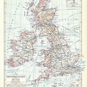
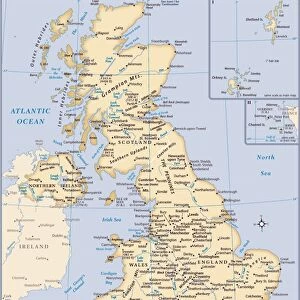
Poster Print : British isles map 1881


![]()
Poster Prints from Fine Art Storehouse
British isles map 1881
Harpers School Geography, New York, Harpers and Brothers, 1881
Unleash your creativity and transform your space into a visual masterpiece!
THEPALMER
Media ID 14756110
© This content is subject to copyright
Great Britain Ireland Scotland
A3 (42 x 29.7cm) Poster Print
Step back in time with our exquisite British Isles Map Print from ThePalmer's Harpers School Geography series, published in New York by Harpers and Brothers in 1881. This vintage poster print depicts intricate detail and historical accuracy, transporting you to a bygone era. The rich colors and meticulous illustrations bring the British Isles to life, making it a stunning addition to any home or office space. Perfect for history enthusiasts, educators, or anyone with a love for antique maps, this poster print is sure to captivate and inspire.
Premium quality poster prints are printed on luxurious semi-gloss satin 270 gsm paper. Our meticulously crafted poster prints offer an affordable option for decorating any space, making them ideal for living rooms, bedrooms, offices and beyond. To ensure your poster arrives in good condition, we roll and send them in strong mailing tubes.
Poster prints are budget friendly enlarged prints in standard poster paper sizes (A0, A1, A2, A3 etc). Whilst poster paper is sometimes thinner and less durable than our other paper types, they are still ok for framing and should last many years. Our Archival Quality Photo Prints and Fine Art Paper Prints are printed on higher quality paper and the choice of which largely depends on your budget.
Estimated Product Size is 30.6cm x 42.6cm (12" x 16.8")
These are individually made so all sizes are approximate
Artwork printed orientated as per the preview above, with portrait (vertical) orientation to match the source image.
FEATURES IN THESE COLLECTIONS
> Fine Art Storehouse
> Map
> Historical Maps
EDITORS COMMENTS
This print showcases a vintage map of the British Isles, dating back to 1881. A true treasure from Harpers School Geography in New York, published by Harpers and Brothers, this piece takes us on a journey through time. The intricate details and delicate lines beautifully depict Great Britain, Ireland, Scotland, and the United Kingdom as they were over a century ago. The map's historical significance is undeniable; it offers an invaluable glimpse into the past, allowing us to explore the geography of these iconic lands during that era. As we gaze upon this artwork by THEPALMER from Fine Art Storehouse, we are transported back to a time when borders were different and nations had distinct identities. The craftsmanship evident in every stroke is awe-inspiring. Each contour reflects meticulous cartographic precision while capturing the essence of these remarkable islands. This print serves as both an educational tool for geography enthusiasts and an exquisite decorative piece for any space. Whether displayed in a classroom or adorning the walls of your home or office, this photograph invites you to immerse yourself in history while appreciating its aesthetic beauty. It sparks curiosity about how landscapes have evolved throughout time and encourages contemplation on our connection with the past. THEPALMER's attention to detail brings out every nuance of this antique map—making it not just a visual delight but also an invitation to explore centuries-old stories etched onto paper.
MADE IN AUSTRALIA
Safe Shipping with 30 Day Money Back Guarantee
FREE PERSONALISATION*
We are proud to offer a range of customisation features including Personalised Captions, Color Filters and Picture Zoom Tools
SECURE PAYMENTS
We happily accept a wide range of payment options so you can pay for the things you need in the way that is most convenient for you
* Options may vary by product and licensing agreement. Zoomed Pictures can be adjusted in the Cart.