Jigsaw Puzzle > Fine Art Storehouse > Map
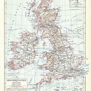
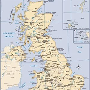
Jigsaw Puzzle : British isles map 1881


![]()
Jigsaw Puzzles from Fine Art Storehouse
British isles map 1881
Harpers School Geography, New York, Harpers and Brothers, 1881
Unleash your creativity and transform your space into a visual masterpiece!
THEPALMER
Media ID 14756110
© This content is subject to copyright
Great Britain Ireland Scotland
Jigsaw Puzzle (500 Pieces)
Discover the historical charm of the British Isles with the Media Storehouse Jigsaw Puzzle featuring the intricately detailed map "British Isles Map 1881" from ThePalmer's Harpers School Geography by Harpers and Brothers, New York. This captivating puzzle, based on an original map published in 1881, invites you on a journey through time as you piece together the intricacies of the British Isles. Immerse yourself in the history and geography of this fascinating region, making this puzzle not only a fun and engaging activity, but also an educational and beautiful addition to your home. Perfect for puzzle enthusiasts, history buffs, or anyone looking for a challenging and rewarding pastime. Get ready to explore the British Isles like never before with Media Storehouse's British Isles Map 1881 Jigsaw Puzzle.
500 piece puzzles are custom made in Australia and hand-finished on 100% recycled 1.6mm thick laminated puzzle boards. There is a level of repetition in jigsaw shapes with each matching piece away from its pair. The completed puzzle measures 40x51cm and is delivered packaged in an attractive presentation box specially designed to fit most mail slots with a unique magnetic lid
Jigsaw Puzzles are an ideal gift for any occasion
Estimated Product Size is 40.3cm x 50.7cm (15.9" x 20")
These are individually made so all sizes are approximate
Artwork printed orientated as per the preview above, with landscape (horizontal) or portrait (vertical) orientation to match the source image.
FEATURES IN THESE COLLECTIONS
> Fine Art Storehouse
> Map
> Historical Maps
EDITORS COMMENTS
This print showcases a vintage map of the British Isles, dating back to 1881. A true treasure from Harpers School Geography in New York, published by Harpers and Brothers, this piece takes us on a journey through time. The intricate details and delicate lines beautifully depict Great Britain, Ireland, Scotland, and the United Kingdom as they were over a century ago. The map's historical significance is undeniable; it offers an invaluable glimpse into the past, allowing us to explore the geography of these iconic lands during that era. As we gaze upon this artwork by THEPALMER from Fine Art Storehouse, we are transported back to a time when borders were different and nations had distinct identities. The craftsmanship evident in every stroke is awe-inspiring. Each contour reflects meticulous cartographic precision while capturing the essence of these remarkable islands. This print serves as both an educational tool for geography enthusiasts and an exquisite decorative piece for any space. Whether displayed in a classroom or adorning the walls of your home or office, this photograph invites you to immerse yourself in history while appreciating its aesthetic beauty. It sparks curiosity about how landscapes have evolved throughout time and encourages contemplation on our connection with the past. THEPALMER's attention to detail brings out every nuance of this antique map—making it not just a visual delight but also an invitation to explore centuries-old stories etched onto paper.
MADE IN AUSTRALIA
Safe Shipping with 30 Day Money Back Guarantee
FREE PERSONALISATION*
We are proud to offer a range of customisation features including Personalised Captions, Color Filters and Picture Zoom Tools
SECURE PAYMENTS
We happily accept a wide range of payment options so you can pay for the things you need in the way that is most convenient for you
* Options may vary by product and licensing agreement. Zoomed Pictures can be adjusted in the Cart.