Fine Art Print > Europe > United Kingdom > Maps
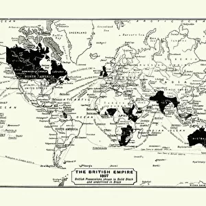
Fine Art Print : Map of the British Empire in 1837


![]()
Fine Art Prints from Fine Art Storehouse
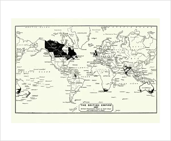
Map of the British Empire in 1837
Map of the British Empire in 1837. At its height, the British Empire was the largest empire in history and, for over a century, was the foremost global power
Unleash your creativity and transform your space into a visual masterpiece!
duncan1890
Media ID 13666689
© duncan1890
1830 1839 78279 95839 British Culture British Empire Empire Ilustration Image Created 1830 1839 Navigational Equipment Retro Revival Styles World Map Image Created 19th Century Retro Styled Victorian Style
20"x16" (+3" Border) Fine Art Print
Step back in time with our exquisite Map of the British Empire in 1837 Fine Art Print from the Media Storehouse collection. This stunning piece, created by the talented artist duncan1890, offers a captivating glimpse into history. At its peak, the British Empire was the largest in the world, shaping global politics and culture for over a century. Bring this piece home to add a touch of historical intrigue and sophistication to any room. Each print is meticulously produced using high-quality materials, ensuring vibrant colors and sharp details that truly bring the map to life. Order yours today and embark on a journey through time.
20x16 image printed on 26x22 Fine Art Rag Paper with 3" (76mm) white border. Our Fine Art Prints are printed on 300gsm 100% acid free, PH neutral paper with archival properties. This printing method is used by museums and art collections to exhibit photographs and art reproductions.
Our fine art prints are high-quality prints made using a paper called Photo Rag. This 100% cotton rag fibre paper is known for its exceptional image sharpness, rich colors, and high level of detail, making it a popular choice for professional photographers and artists. Photo rag paper is our clear recommendation for a fine art paper print. If you can afford to spend more on a higher quality paper, then Photo Rag is our clear recommendation for a fine art paper print.
Estimated Image Size (if not cropped) is 50.8cm x 35.9cm (20" x 14.1")
Estimated Product Size is 66cm x 55.9cm (26" x 22")
These are individually made so all sizes are approximate
Artwork printed orientated as per the preview above, with landscape (horizontal) orientation to match the source image.
FEATURES IN THESE COLLECTIONS
> Europe
> United Kingdom
> Maps
> Maps and Charts
> British Empire Maps
> Maps and Charts
> Related Images
> Maps and Charts
> World
> Fine Art Storehouse
> Map
> Historical Maps
EDITORS COMMENTS
This print showcases a remarkable piece of history - the Map of the British Empire in 1837. With its retro revival and 19th-century style, this antique engraved image takes us back to an era when the British Empire reigned supreme. Created between 1830 and 1839, during the height of its power, this illustration represents a pivotal moment in world history. The grandeur of the British Empire is beautifully depicted in this Victorian-style map. Its vast territories spanned across continents, making it the largest empire ever known. For over a century, Britain held unparalleled global influence and was considered the foremost global power. As we gaze upon this meticulously crafted cartography, we are transported to a time when navigational equipment played a crucial role in expanding empires. The attention to detail is awe-inspiring as every corner of this world map reveals intricate borders and territories that once fell under British rule. This image not only captures an important period but also reflects on British culture and its impact on diverse cultures around the globe. It serves as a reminder of our shared past and how historical events shape our present-day world. Duncan1890's artistry has breathed new life into this vintage masterpiece from 1837, allowing us to appreciate both its historical significance and artistic beauty anew.
MADE IN AUSTRALIA
Safe Shipping with 30 Day Money Back Guarantee
FREE PERSONALISATION*
We are proud to offer a range of customisation features including Personalised Captions, Color Filters and Picture Zoom Tools
SECURE PAYMENTS
We happily accept a wide range of payment options so you can pay for the things you need in the way that is most convenient for you
* Options may vary by product and licensing agreement. Zoomed Pictures can be adjusted in the Cart.