Fine Art Print > Europe > United Kingdom > England > Bristol > Easton
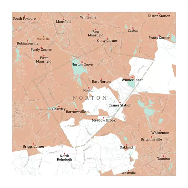
Fine Art Print : MA Bristol Norton Vector Road Map


![]()
Fine Art Prints from Fine Art Storehouse
MA Bristol Norton Vector Road Map
MA Bristol Norton Vector Road Map. All source data is in the public domain. U.S. Census Bureau Census Tiger. Used Layers: areawater, linearwater, roads, rails, cousub, pointlm, uac10
Unleash your creativity and transform your space into a visual masterpiece!
Frank Ramspott
Media ID 20689059
© Frank Ramspott, all rights reserved
Bristol City Map Computer Graphic County Digital Composite District Geographical Border Massachusetts Road Map Text Vector Chartley Digitally Generated Image Easton Mansfield Meadow Brook Norton Norton Grove Taunton
20"x20" (+3" Border) Fine Art Print
Discover the captivating fusion of art and cartography with the MA Bristol Norton Vector Road Map by Frank Ramspott from the Fine Art Storehouse. This exquisite fine art print transforms a classic road map into a stunning work of art, meticulously crafted using public domain data from the U.S. Census Bureau. The intricate details of the map are brought to life through Frank Ramspott's unique vector art style, showcasing the roads, rails, waterways, and points of interest in a whole new light. Add a touch of contemporary artistry to your home or office decor with this one-of-a-kind, museum-quality fine art print from the Fine Art Storehouse.
20x20 image printed on 26x26 Fine Art Rag Paper with 3" (76mm) white border. Our Fine Art Prints are printed on 300gsm 100% acid free, PH neutral paper with archival properties. This printing method is used by museums and art collections to exhibit photographs and art reproductions.
Our fine art prints are high-quality prints made using a paper called Photo Rag. This 100% cotton rag fibre paper is known for its exceptional image sharpness, rich colors, and high level of detail, making it a popular choice for professional photographers and artists. Photo rag paper is our clear recommendation for a fine art paper print. If you can afford to spend more on a higher quality paper, then Photo Rag is our clear recommendation for a fine art paper print.
Estimated Image Size (if not cropped) is 50.8cm x 50.8cm (20" x 20")
Estimated Product Size is 66cm x 66cm (26" x 26")
These are individually made so all sizes are approximate
Artwork printed orientated as per the preview above, with landscape (horizontal) or portrait (vertical) orientation to match the source image.
FEATURES IN THESE COLLECTIONS
> Animals
> Mammals
> Cats (Wild)
> Tiger
> Animals
> Mammals
> Muridae
> Water Mouse
> Arts
> Contemporary art
> Digital artwork
> Street art
> Arts
> Landscape paintings
> Waterfall and river artworks
> River artworks
> Arts
> Portraits
> Pop art gallery
> Street art portraits
> Arts
> Street art graffiti
> Digital art
> Digital paintings
> Europe
> United Kingdom
> England
> Bristol
> Bristol
> Europe
> United Kingdom
> England
> Bristol
> Easton
> Maps and Charts
> Related Images
> Popular Themes
> Lake District
> Fine Art Storehouse
> Map
> Reference Maps
EDITORS COMMENTS
This vibrant and detailed print showcases the MA Bristol Norton Vector Road Map, a stunning piece of cartography created by Frank Ramspott. With all source data in the public domain, this map is an accurate representation of the Massachusetts county district. The digital composite image features various layers including areawater, linearwater, roads, rails, cousub, pointlm, and uac10. These layers beautifully highlight the geographical borders and physical geography of the area. In this color image with no people present, every street name and town is clearly labeled for easy navigation. From Barrowsville to Winnecunnet and from Chartley to Norton Grove - all towns within Bristol County are included on this comprehensive map. The inclusion of rivers and lakes adds depth to the design while emphasizing important water bodies in the region such as Whittenton River. Whether you're a local resident or a visitor exploring Massachusetts' cities like Taunton or Easton, this road map provides essential information for your journey. Digitally generated using computer graphics technology, this visually appealing vector image captures every detail with precision. Perfect for home decor or office display purposes alike; it's an ideal choice for those who appreciate both artistry and functionality in their surroundings
MADE IN AUSTRALIA
Safe Shipping with 30 Day Money Back Guarantee
FREE PERSONALISATION*
We are proud to offer a range of customisation features including Personalised Captions, Color Filters and Picture Zoom Tools
SECURE PAYMENTS
We happily accept a wide range of payment options so you can pay for the things you need in the way that is most convenient for you
* Options may vary by product and licensing agreement. Zoomed Pictures can be adjusted in the Cart.