Fine Art Print > Europe > United Kingdom > England > Maps
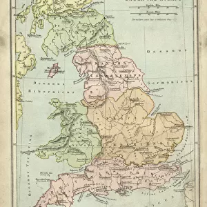
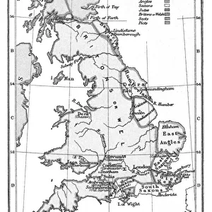
Fine Art Print : Antique map of Britain under the Anglo Saxons


![]()
Fine Art Prints from Fine Art Storehouse
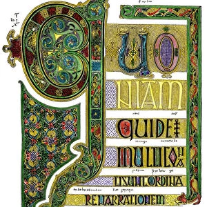
Antique map of Britain under the Anglo Saxons
Unleash your creativity and transform your space into a visual masterpiece!
duncan1890
Media ID 14549471
© This content is subject to copyright
1870s Ancient Civilisation Ancient History Bad Condition British Colour Colours Condition English Equipment Faded Great Britain Image Created 1870 1879 Medieval Middle Ages Navigational Equipment Northern Europe Retro Saxon Styles Supplies Traditional United Kingdom
20"x16" (+3" Border) Fine Art Print
Step back in time with our exquisite Antique Map of Britain under the Anglo Saxons, skillfully crafted by artist duncan1890 from the Fine Art Storehouse. This stunning fine art print transports you to a bygone era, meticulously capturing the intricate details of the British Isles during the Anglo-Saxon period. The rich, earthy tones and authentic cartography evoke a sense of history and tradition. Perfect for adding a touch of timeless charm to any room, this fine art print makes a captivating conversation starter and a cherished addition to your collection.
20x16 image printed on 26x22 Fine Art Rag Paper with 3" (76mm) white border. Our Fine Art Prints are printed on 300gsm 100% acid free, PH neutral paper with archival properties. This printing method is used by museums and art collections to exhibit photographs and art reproductions.
Our fine art prints are high-quality prints made using a paper called Photo Rag. This 100% cotton rag fibre paper is known for its exceptional image sharpness, rich colors, and high level of detail, making it a popular choice for professional photographers and artists. Photo rag paper is our clear recommendation for a fine art paper print. If you can afford to spend more on a higher quality paper, then Photo Rag is our clear recommendation for a fine art paper print.
Estimated Image Size (if not cropped) is 35.9cm x 50.8cm (14.1" x 20")
Estimated Product Size is 55.9cm x 66cm (22" x 26")
These are individually made so all sizes are approximate
Artwork printed orientated as per the preview above, with portrait (vertical) orientation to match the source image.
FEATURES IN THESE COLLECTIONS
> Arts
> Art Movements
> Medieval Art
> Europe
> Related Images
> Europe
> United Kingdom
> England
> Maps
> Europe
> United Kingdom
> England
> Paintings
> Europe
> United Kingdom
> England
> Posters
> Europe
> United Kingdom
> England
> Related Images
> Europe
> United Kingdom
> Related Images
> Historic
> Historical fashion trends
> Medieval fashion trends
> Maps and Charts
> Early Maps
> Maps and Charts
> Related Images
> Popular Themes
> Maps and Charts
> Fine Art Storehouse
> Map
> Historical Maps
> Fine Art Storehouse
> Top Sellers - Art Prints
EDITORS COMMENTS
This print takes us back in time to the ancient civilization of Britain under the rule of the Anglo Saxons. Created in the 1870s, this antique map showcases a remarkable piece of history with its intricate details and faded colors. Despite its bad condition, it exudes an undeniable charm that transports us to a bygone era. The engraving skillfully depicts the geographical landscape of Great Britain during medieval times, offering a glimpse into how navigational equipment was utilized during that period. The illustration and painting techniques employed in this image showcase traditional styles prevalent in 19th-century cartography. As we explore this vintage artwork, we can't help but appreciate the meticulous craftsmanship involved in creating such maps before modern technology took over. It serves as a reminder of our rich heritage and allows us to connect with our ancestors who once roamed these lands. Though worn by time, this print evokes a sense of nostalgia and curiosity about England's past. It invites us to delve deeper into British history and discover more about the fascinating Anglo Saxon era. Duncan1890 has preserved an important piece of European history through this lithograph, ensuring that future generations can admire and learn from it. This print is not just an old-fashioned relic; it is a window into our collective past – one that deserves appreciation for its cultural significance.
MADE IN AUSTRALIA
Safe Shipping with 30 Day Money Back Guarantee
FREE PERSONALISATION*
We are proud to offer a range of customisation features including Personalised Captions, Color Filters and Picture Zoom Tools
SECURE PAYMENTS
We happily accept a wide range of payment options so you can pay for the things you need in the way that is most convenient for you
* Options may vary by product and licensing agreement. Zoomed Pictures can be adjusted in the Cart.