Fine Art Print > Maps and Charts > World
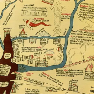
Fine Art Print : The Ebstorf Map, c. 1300. Artist: Anonymous master


![]()
Fine Art Prints from Heritage Images
The Ebstorf Map, c. 1300. Artist: Anonymous master
The Ebstorf Map, c. 1300. Found in the collection of Ebstorf Abbey, Lueneburg
Heritage Images features heritage image collections
Media ID 15023494
© Fine Art Images
Anonymous Master Watercolour On Parchment World Map Mappa Mundi
20"x20" (+3" Border) Fine Art Print
Discover the mysteries of the past with our exquisite selection of Fine Art Prints from Media Storehouse. This captivating piece showcases the enigmatic Ebstorf Map, an anonymous masterpiece from around 1300. Originating from the collection of Ebstorf Abbey in Lueneburg, Germany, this intricately detailed map is a testament to the artistic and cartographic achievements of the Middle Ages. Bring the rich history and allure of this ancient world into your home or office with our museum-quality prints, expertly reproduced from the original Heritage Images source. Experience the beauty and intrigue of the past, one print at a time.
20x20 image printed on 26x26 Fine Art Rag Paper with 3" (76mm) white border. Our Fine Art Prints are printed on 300gsm 100% acid free, PH neutral paper with archival properties. This printing method is used by museums and art collections to exhibit photographs and art reproductions.
Our fine art prints are high-quality prints made using a paper called Photo Rag. This 100% cotton rag fibre paper is known for its exceptional image sharpness, rich colors, and high level of detail, making it a popular choice for professional photographers and artists. Photo rag paper is our clear recommendation for a fine art paper print. If you can afford to spend more on a higher quality paper, then Photo Rag is our clear recommendation for a fine art paper print.
Estimated Image Size (if not cropped) is 50.8cm x 50.8cm (20" x 20")
Estimated Product Size is 66cm x 66cm (26" x 26")
These are individually made so all sizes are approximate
Artwork printed orientated as per the preview above, with landscape (horizontal) or portrait (vertical) orientation to match the source image.
FEATURES IN THESE COLLECTIONS
> Maps and Charts
> Related Images
> Maps and Charts
> World
The Ebstorf Map, c. 1300 - A Glimpse into Medieval Cartography
EDITORS COMMENTS
. This print showcases the remarkable "Ebstorf Map" a masterpiece of medieval cartography created by an anonymous master in the year 1300. Found within the esteemed collection of Ebstorf Abbey in Lueneburg, Germany, this world map offers a fascinating insight into how our ancestors perceived and represented their known world. Crafted with meticulous detail on watercolour-painted parchment, this mappa mundi is a testament to both artistic skill and geographical knowledge of its time. Measuring approximately three meters in diameter, it presents Europe at its center while depicting other continents such as Africa and Asia surrounding it. The Ebstorf Map not only serves as a navigational tool but also conveys religious symbolism prevalent during the Middle Ages. Biblical scenes are intricately woven throughout the map's borders, illustrating stories from both Old and New Testaments. These illustrations remind viewers that faith played an integral role in shaping people's understanding of geography during this era. Preserved through centuries of history, this fine art piece continues to captivate scholars and enthusiasts alike with its unique blend of artistic beauty and historical significance. It stands as a testament to human curiosity about our place in the world and serves as a reminder that maps have always been more than mere representations; they reflect cultural beliefs, aspirations, and perceptions. As we gaze upon this exquisite print capturing The Ebstorf Map's intricate details today
MADE IN AUSTRALIA
Safe Shipping with 30 Day Money Back Guarantee
FREE PERSONALISATION*
We are proud to offer a range of customisation features including Personalised Captions, Color Filters and Picture Zoom Tools
SECURE PAYMENTS
We happily accept a wide range of payment options so you can pay for the things you need in the way that is most convenient for you
* Options may vary by product and licensing agreement. Zoomed Pictures can be adjusted in the Cart.