Fine Art Print > Arts > Artists > A > John White Alexander
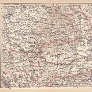
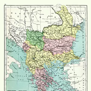
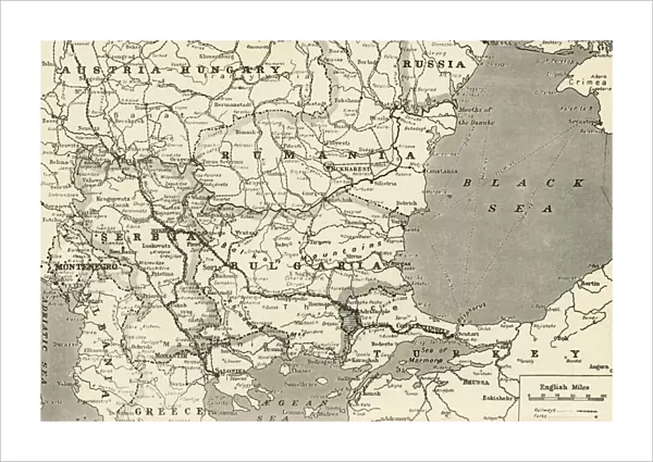
Fine Art Print : Map Showing the Relation of Serbia to Neighbouring States, 1916. Creator: Unknown


![]()
Fine Art Prints from Heritage Images
Map Showing the Relation of Serbia to Neighbouring States, 1916. Creator: Unknown
Map Showing the Relation of Serbia to Neighbouring States, 1916. The Serbian campaign was fought from late July 1914, when Austria-Hungary invaded Serbia at the outset of World War I. From " The War Illustrated Album De Luxe - Volume IV. The Summer Campaign - 1915", edited by J. A. Hammerton. [The Amalgamated Press, Limited, London, 1916]
Heritage Images features heritage image collections
Media ID 19661415
© The Print Collector/Heritage Images
Album Amalgamated Press Amalgamated Press Limited Amalgamated Press Ltd Austria Hungary Austro Hungarian Baltic Sea Bulgaria Bulgarian Hammerton Hammerton J A Hammerton Ja Hammerton Sir John Alexander J A Hammerton Ja Hammerton John Hammerton Romania Romanian Serbia Serbia Yugoslavia Serbian Serbian Campaign Sir John Alexander Sir John Alexander Hammerton Sir John Hammerton Strategic Strategy Summer Campaign 1915 Territorial Territory The Amalgamated Press The War Illustrated Yugoslavia
21"x14" (+3" Border) Fine Art Print
Step back in time with our exquisite Fine Art Print of a rare and historic map from Heritage Images. This captivating piece, titled "Map Showing the Relation of Serbia to Neighbouring States, 1916," offers a fascinating glimpse into the past. Created during the tumultuous period of World War I, this map illustrates the strategic location of Serbia in relation to its neighboring states. The intricate details and vibrant colors bring the history of this significant time to life. Add this unique and enlightening piece to your collection and let the story of the Serbian campaign unfold before your eyes.
21x14 image printed on 27x20 Fine Art Rag Paper with 3" (76mm) white border. Our Fine Art Prints are printed on 300gsm 100% acid free, PH neutral paper with archival properties. This printing method is used by museums and art collections to exhibit photographs and art reproductions.
Our fine art prints are high-quality prints made using a paper called Photo Rag. This 100% cotton rag fibre paper is known for its exceptional image sharpness, rich colors, and high level of detail, making it a popular choice for professional photographers and artists. Photo rag paper is our clear recommendation for a fine art paper print. If you can afford to spend more on a higher quality paper, then Photo Rag is our clear recommendation for a fine art paper print.
Estimated Image Size (if not cropped) is 53.3cm x 35.5cm (21" x 14")
Estimated Product Size is 68.6cm x 50.8cm (27" x 20")
These are individually made so all sizes are approximate
Artwork printed orientated as per the preview above, with landscape (horizontal) orientation to match the source image.
FEATURES IN THESE COLLECTIONS
> Arts
> Artists
> A
> John White Alexander
> Arts
> Artists
> W
> John White
> Europe
> Austria
> Related Images
> Europe
> Bulgaria
> Related Images
EDITORS COMMENTS
This print titled "Map Showing the Relation of Serbia to Neighbouring States, 1916" takes us back to a significant moment in history during World War I. The creator of this powerful image remains unknown, but its impact is undeniable. The map showcases the strategic positioning of Serbia amidst its neighboring states, providing valuable insight into the military campaigns that unfolded during this tumultuous time. As Austria-Hungary invaded Serbia in late July 1914, marking the beginning of World War I, this map serves as a historical artifact capturing an important chapter in global conflict. Taken from "The War Illustrated Album De Luxe - Volume IV: The Summer Campaign - 1915" edited by J. A. Hammerton, this print offers viewers a glimpse into the geographical features and territorial boundaries that shaped wartime strategies. From Romania to Bulgaria and even reaching as far as the Baltic Sea, each country's role becomes apparent on this meticulously detailed map. As we reflect upon these events from over a century ago, it is crucial to remember the sacrifices made by those involved in such conflicts. This print not only provides historical context but also invites us to ponder how borders have shifted and alliances transformed since then. Preserved by Heritage Images for future generations to study and appreciate, let us honor both the known and unknown individuals who played their part in shaping our world today through their actions during World War I.
MADE IN AUSTRALIA
Safe Shipping with 30 Day Money Back Guarantee
FREE PERSONALISATION*
We are proud to offer a range of customisation features including Personalised Captions, Color Filters and Picture Zoom Tools
SECURE PAYMENTS
We happily accept a wide range of payment options so you can pay for the things you need in the way that is most convenient for you
* Options may vary by product and licensing agreement. Zoomed Pictures can be adjusted in the Cart.