Fine Art Print > Europe > United Kingdom > England > London > Museums > British Library
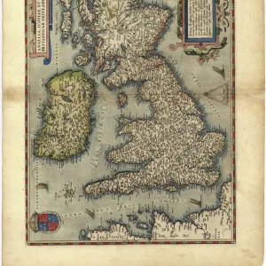
Fine Art Print : Matthew Pariss Map of Great Britain showing rivers & towns in the south of England & part of Wales, c. 1250 (1944)
")


![]()
Fine Art Prints from Heritage Images
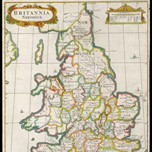
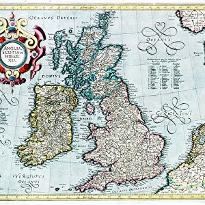
Matthew Pariss Map of Great Britain showing rivers & towns in the south of England & part of Wales, c. 1250 (1944)
Many place-names are still recognisable today. The word Auster, written over the English Channel at the bottom, refers to wind bringing heavy cloud cover and fog. Map drawn by the historian Matthew Paris, a monk at St Albans Abbey. Cotton MS Claudius D.vi, f.12v, manuscript in the British Library, London. From " British Maps and Map-Makers", by Edward Lynam. [Collins, London, 1944]
Heritage Images features heritage image collections
Media ID 19777528
© The Print Collector/Heritage Images
Britain In Pictures Channel Coastline Collins Cornwall Dorset East Anglia Edward Edward Lynam English Channel Lynam Matthew Rivers Social History Wales William Collins William Collins And Sons William Collins Sons Wind Windy Graphic Design Matthew Paris Thirteenth Century West Country
20"x16" (+3" Border) Fine Art Print
Step back in time with our exquisite Matthew Paris Map of Great Britain from the Media Storehouse Fine Art Prints collection. Dating back to 1250, as depicted in this 1944 Heritage Images photograph, this intricately detailed map showcases the rivers and towns in the south of England and part of Wales. Many place-names, such as London, Bath, and Bristol, are still recognizable today, offering a fascinating glimpse into the historical geography of the region. The map also features the label "Auster" over the English Channel, indicating the presence of the wind bringing heavy cloud cover and fog. Add an air of history and sophistication to your home or office with this stunning and authentic piece of cartographic art.
20x16 image printed on 26x22 Fine Art Rag Paper with 3" (76mm) white border. Our Fine Art Prints are printed on 300gsm 100% acid free, PH neutral paper with archival properties. This printing method is used by museums and art collections to exhibit photographs and art reproductions.
Our fine art prints are high-quality prints made using a paper called Photo Rag. This 100% cotton rag fibre paper is known for its exceptional image sharpness, rich colors, and high level of detail, making it a popular choice for professional photographers and artists. Photo rag paper is our clear recommendation for a fine art paper print. If you can afford to spend more on a higher quality paper, then Photo Rag is our clear recommendation for a fine art paper print.
Estimated Image Size (if not cropped) is 50.8cm x 40.6cm (20" x 16")
Estimated Product Size is 66cm x 55.9cm (26" x 22")
These are individually made so all sizes are approximate
Artwork printed orientated as per the preview above, with landscape (horizontal) orientation to match the source image.
FEATURES IN THESE COLLECTIONS
> Animals
> Mammals
> Muridae
> Fortior
> Arts
> Art Movements
> Medieval Art
> Arts
> Artists
> C
> William Collins
> Arts
> Landscape paintings
> Waterfall and river artworks
> River artworks
> Europe
> France
> Paris
> Maps
> Europe
> United Kingdom
> England
> Cornwall
> Related Images
> Europe
> United Kingdom
> England
> Dorset
> Related Images
> Europe
> United Kingdom
> England
> London
> Museums
> British Library
> Europe
> United Kingdom
> England
> London
> Weather
> Europe
> United Kingdom
> England
> Maps
EDITORS COMMENTS
This print showcases Matthew Paris' Map of Great Britain, offering a glimpse into the country's geography and history during the 13th century. Created around 1250, this medieval masterpiece reveals rivers, towns, and even weather patterns in the southern region of England and parts of Wales. The map's intricate design and vivid colors draw attention to its meticulous details. As we examine this historical artifact, it becomes apparent that many place-names depicted on the map are still recognizable today, demonstrating how some locations have retained their identity over centuries. Notably, the word "Auster" is inscribed over the English Channel at the bottom of the map, signifying wind patterns associated with heavy cloud cover and fog. Matthew Paris himself was a historian and monk at St Albans Abbey who dedicated his talents to cartography. This particular manuscript is preserved in London's British Library as Cotton MS Claudius D. vi. Its inclusion in Edward Lynam's book "British Maps and Map-Makers" further solidifies its significance within cartographic studies. The print allows us to appreciate both the artistic beauty of this medieval map as well as its valuable insights into Britain's social history. It serves as a reminder of our rich heritage while highlighting how geographical features have shaped our understanding of different regions throughout time.
MADE IN AUSTRALIA
Safe Shipping with 30 Day Money Back Guarantee
FREE PERSONALISATION*
We are proud to offer a range of customisation features including Personalised Captions, Color Filters and Picture Zoom Tools
SECURE PAYMENTS
We happily accept a wide range of payment options so you can pay for the things you need in the way that is most convenient for you
* Options may vary by product and licensing agreement. Zoomed Pictures can be adjusted in the Cart.