Fine Art Print > Asia > Afghanistan > Maps
Fine Art Print : Map / Afghanistan C1860S


![]()
Fine Art Prints from Mary Evans Picture Library
Map / Afghanistan C1860S
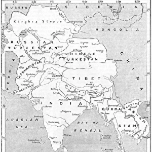
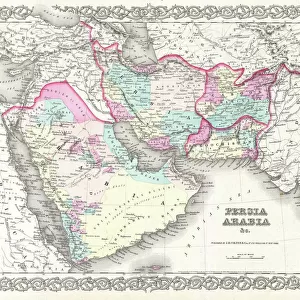
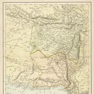
Map of Afghanistan and Beluchistan (note camel routes are measured in days, not miles)
Mary Evans Picture Library makes available wonderful images created for people to enjoy over the centuries
Media ID 608855
© Mary Evans Picture Library 2015 - https://copyrighthub.org/s0/hub1/creation/maryevans/MaryEvansPictureID/10114187
Afghanistan Camel Days Maps Measured Miles Note Routes Beluchistan
20"x16" (+3" Border) Fine Art Print
Discover the captivating allure of the past with our exquisite selection of Fine Art Prints from Media Storehouse, featuring the mesmerizing Map of Afghanistan and Beluchistan from Mary Evans Picture Library. Dated back to the mid-19th century, this intricately detailed map showcases the vast expanse of the region, with camel routes meticulously measured in days instead of miles. Transport yourself back in time and adorn your walls with this stunning piece of historical cartography, a perfect addition to any home or office collection.
20x16 image printed on 26x22 Fine Art Rag Paper with 3" (76mm) white border. Our Fine Art Prints are printed on 300gsm 100% acid free, PH neutral paper with archival properties. This printing method is used by museums and art collections to exhibit photographs and art reproductions.
Our fine art prints are high-quality prints made using a paper called Photo Rag. This 100% cotton rag fibre paper is known for its exceptional image sharpness, rich colors, and high level of detail, making it a popular choice for professional photographers and artists. Photo rag paper is our clear recommendation for a fine art paper print. If you can afford to spend more on a higher quality paper, then Photo Rag is our clear recommendation for a fine art paper print.
Estimated Image Size (if not cropped) is 40.6cm x 49.3cm (16" x 19.4")
Estimated Product Size is 55.9cm x 66cm (22" x 26")
These are individually made so all sizes are approximate
Artwork printed orientated as per the preview above, with portrait (vertical) orientation to match the source image.
FEATURES IN THESE COLLECTIONS
> Asia
> Afghanistan
> Maps
> Asia
> Afghanistan
> Related Images
> Asia
> Related Images
> Maps and Charts
> Early Maps
> Maps and Charts
> Related Images
EDITORS COMMENTS
This fascinating print from Mary Evans Picture Library showcases a historical map of Afghanistan and Beluchistan dating back to the 1860s. The intricate details on the map provide a glimpse into the past, highlighting important camel routes that were measured in days rather than miles. This unique feature offers insight into the mode of transportation and travel distances during that time period.
The map itself is a testament to the rich history of Asia, specifically focusing on Afghanistan and Beluchistan. It serves as a valuable educational tool for those interested in studying geography, history, or cultural heritage. The careful craftsmanship and attention to detail are evident in every aspect of this vintage map.
As we gaze upon this piece of art, we are transported back in time to an era where exploration and discovery were at the forefront. The significance of camel routes being measured in days reminds us of the challenges faced by travelers navigating through these regions centuries ago.
Overall, this print is not just a visual representation but also a historical document that sheds light on the complexities and nuances of Asian geography. It is truly a treasure trove for history buffs and enthusiasts alike.
MADE IN AUSTRALIA
Safe Shipping with 30 Day Money Back Guarantee
FREE PERSONALISATION*
We are proud to offer a range of customisation features including Personalised Captions, Color Filters and Picture Zoom Tools
SECURE PAYMENTS
We happily accept a wide range of payment options so you can pay for the things you need in the way that is most convenient for you
* Options may vary by product and licensing agreement. Zoomed Pictures can be adjusted in the Cart.