Home > Asia > Taiwan > Maps
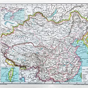
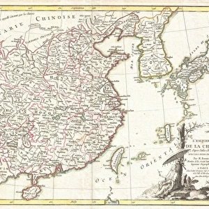
1799, Clement Cruttwell Map of China, Korea, and Taiwan, topography, cartography

![]()
Wall Art and Photo Gifts from Liszt Collection
1799, Clement Cruttwell Map of China, Korea, and Taiwan, topography, cartography
1799, Clement Cruttwell Map of China, Korea, and Taiwan
Liszt Collection of nineteenth-century engravings and images to browse and enjoy
Media ID 14004858
© Artokoloro Quint Lox Limited
1799 Korea Antique Map Atlas Chart Geographic Latitude Longitude Mappa Mundi Old Antique Plan Old Antique View Old Map Ols Antique Map Rare Old Maps Topo
FEATURES IN THESE COLLECTIONS
> Maps and Charts
> Early Maps
> Maps and Charts
> World
EDITORS COMMENTS
This print showcases the intricate beauty of the 1799 Clement Cruttwell Map of China, Korea, and Taiwan. A true masterpiece in cartography, this vintage map takes us back in time to an era when exploration and discovery were at their peak. With its topographical details meticulously illustrated, it offers a glimpse into the geographical features of these ancient lands. The artistry displayed on this old paper map is simply awe-inspiring. The carefully crafted grid lines, latitude and longitude markings, and geometric precision demonstrate the immense skill and dedication that went into creating such a historical artifact. As we delve deeper into its rich history, we are transported to a world where navigation relied on maps like these for journeys across vast regions. This rare antique map not only serves as a valuable tool for understanding past civilizations but also doubles as a decorative piece that adds character to any space. Its aged appearance evokes nostalgia while reminding us of our planet's ever-changing landscape throughout time. Whether you are an avid collector or simply appreciate the beauty of historical artifacts, this Clement Cruttwell Map is sure to captivate your imagination with its intricate details and fascinating depiction of China, Korea, and Taiwan from centuries ago.
MADE IN AUSTRALIA
Safe Shipping with 30 Day Money Back Guarantee
FREE PERSONALISATION*
We are proud to offer a range of customisation features including Personalised Captions, Color Filters and Picture Zoom Tools
SECURE PAYMENTS
We happily accept a wide range of payment options so you can pay for the things you need in the way that is most convenient for you
* Options may vary by product and licensing agreement. Zoomed Pictures can be adjusted in the Cart.