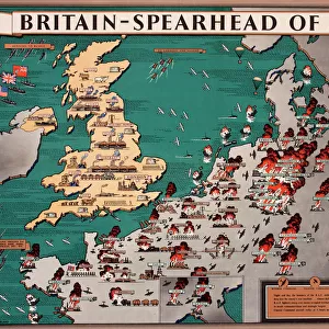
Fine Art Print : Map of Japanese invasion receding by G. H. Davis


![]()
Fine Art Prints from Mary Evans Picture Library
Map of Japanese invasion receding by G. H. Davis
A pictorial map of the Pacific area, showing how the wave of Japanese invasion receded as a result of the Allied strategy during the Second World War. Showing Japans conquests, dates of occupation, and reconquests. Date: 1945
Mary Evans Picture Library makes available wonderful images created for people to enjoy over the centuries
Media ID 14133549
© Illustrated London News Ltd/Mary Evans
1945 Allied Area Conquests Dates Davis Guinea Invasion Maps Occupation Pacific Philippines Pictorial Power Singapore Strategy Struggle Sumatra Receded
20"x16" (+3" Border) Fine Art Print
Discover the rich historical depth of the past with our exquisite Fine Art Print of 'Map of Japanese Invasion Receding' by G. H. Davis, available through Media Storehouse in partnership with Mary Evans Prints Online. This captivating pictorial map offers a unique perspective on the Pacific Theatre during World War II, illustrating the strategic retreat of Japanese forces as the tide turned in favor of the Allies. Add this stunning piece to your collection and bring a piece of history into your home or office.
20x16 image printed on 26x22 Fine Art Rag Paper with 3" (76mm) white border. Our Fine Art Prints are printed on 300gsm 100% acid free, PH neutral paper with archival properties. This printing method is used by museums and art collections to exhibit photographs and art reproductions.
Our fine art prints are high-quality prints made using a paper called Photo Rag. This 100% cotton rag fibre paper is known for its exceptional image sharpness, rich colors, and high level of detail, making it a popular choice for professional photographers and artists. Photo rag paper is our clear recommendation for a fine art paper print. If you can afford to spend more on a higher quality paper, then Photo Rag is our clear recommendation for a fine art paper print.
Estimated Image Size (if not cropped) is 50.8cm x 35.5cm (20" x 14")
Estimated Product Size is 66cm x 55.9cm (26" x 22")
These are individually made so all sizes are approximate
Artwork printed orientated as per the preview above, with landscape (horizontal) orientation to match the source image.
EDITORS COMMENTS
This pictorial map, titled "Map of Japanese Invasion Receding," is a testament to the historical turning point of the Pacific Theater during World War II. Created by renowned cartographer G.H. Davis in 1945, this map offers a visual representation of the ebb and flow of the Japanese invasion and subsequent Allied reconquests. The vibrant and intricately detailed map displays the vast Pacific area, with a focus on the East and Eastern Pacific Ocean, China, the Philippines, Singapore, Sumatra, New Guinea, and Australia. The map's central theme is the Japanese conquests, meticulously marked with dates of occupation, providing a visual timeline of the invasion's progression. However, the true power of this map lies in its depiction of the Japanese invasion's recession. As the Allied strategy began to take hold, the once-expanding wave of Japanese control began to recede, as evidenced by the reconquered territories marked on the map. The map serves as a poignant reminder of the intense power struggle that defined the wartime Pacific, and the eventual triumph of the Allied forces. The map's historical significance is further emphasized by its inclusion of key dates and locations, offering viewers a unique perspective on the Pacific War's pivotal moments. This and informative map is a must-have for history enthusiasts, educators, and anyone interested in understanding the complexities of World War II's Pacific Theater.
MADE IN AUSTRALIA
Safe Shipping with 30 Day Money Back Guarantee
FREE PERSONALISATION*
We are proud to offer a range of customisation features including Personalised Captions, Color Filters and Picture Zoom Tools
SECURE PAYMENTS
We happily accept a wide range of payment options so you can pay for the things you need in the way that is most convenient for you
* Options may vary by product and licensing agreement. Zoomed Pictures can be adjusted in the Cart.