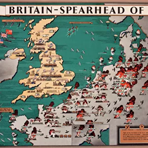
Photo Mug : Map of Japanese invasion receding by G. H. Davis


![]()
Home Decor from Mary Evans Picture Library
Map of Japanese invasion receding by G. H. Davis
A pictorial map of the Pacific area, showing how the wave of Japanese invasion receded as a result of the Allied strategy during the Second World War. Showing Japans conquests, dates of occupation, and reconquests. Date: 1945
Mary Evans Picture Library makes available wonderful images created for people to enjoy over the centuries
Media ID 14133549
© Illustrated London News Ltd/Mary Evans
1945 Allied Area Conquests Dates Davis Guinea Invasion Maps Occupation Pacific Philippines Pictorial Power Singapore Strategy Struggle Sumatra Receded
Photo Mug
Introducing the Media Storehouse Photo Mug, featuring an intriguing historical image of "Map of Japanese Invasion Receding by G. H. Davis." This captivating pictorial map, sourced from Mary Evans Prints Online, offers a unique and educational perspective on the Pacific theater during World War II. Witness the strategic retreat of Japanese forces as the tide of battle turned in favor of the Allies. Each mug holds your favorite beverage and serves as a thought-provoking conversation starter. Embrace history and enjoy a daily dose of inspiration with every sip.
A personalised photo mug blends sentimentality with functionality, making an ideal gift for cherished loved ones, close friends, or valued colleagues. Preview may show both sides of the same mug.
Elevate your coffee or tea experience with our premium white ceramic mug. Its wide, comfortable handle makes drinking easy, and you can rely on it to be both microwave and dishwasher safe. Sold in single units, preview may show both sides of the same mug so you can see how the picture wraps around.
Mug Size is 8.1cm high x 9.6cm diameter (3.2" x 3.8")
These are individually made so all sizes are approximate
EDITORS COMMENTS
This pictorial map, titled "Map of Japanese Invasion Receding," is a testament to the historical turning point of the Pacific Theater during World War II. Created by renowned cartographer G.H. Davis in 1945, this map offers a visual representation of the ebb and flow of the Japanese invasion and subsequent Allied reconquests. The vibrant and intricately detailed map displays the vast Pacific area, with a focus on the East and Eastern Pacific Ocean, China, the Philippines, Singapore, Sumatra, New Guinea, and Australia. The map's central theme is the Japanese conquests, meticulously marked with dates of occupation, providing a visual timeline of the invasion's progression. However, the true power of this map lies in its depiction of the Japanese invasion's recession. As the Allied strategy began to take hold, the once-expanding wave of Japanese control began to recede, as evidenced by the reconquered territories marked on the map. The map serves as a poignant reminder of the intense power struggle that defined the wartime Pacific, and the eventual triumph of the Allied forces. The map's historical significance is further emphasized by its inclusion of key dates and locations, offering viewers a unique perspective on the Pacific War's pivotal moments. This and informative map is a must-have for history enthusiasts, educators, and anyone interested in understanding the complexities of World War II's Pacific Theater.
MADE IN AUSTRALIA
Safe Shipping with 30 Day Money Back Guarantee
FREE PERSONALISATION*
We are proud to offer a range of customisation features including Personalised Captions, Color Filters and Picture Zoom Tools
SECURE PAYMENTS
We happily accept a wide range of payment options so you can pay for the things you need in the way that is most convenient for you
* Options may vary by product and licensing agreement. Zoomed Pictures can be adjusted in the Cart.