Fine Art Print > Europe > France > Paris > Maps
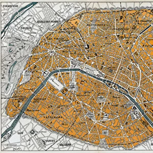
Fine Art Print : Map of Paris in 1908 with geographic and demographical data


![]()
Fine Art Prints from Mary Evans Picture Library
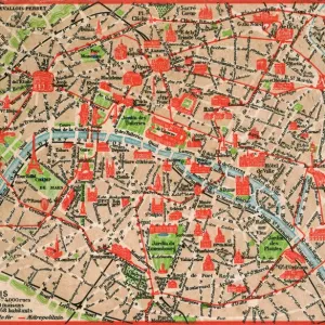
Map of Paris in 1908 with geographic and demographical data
Map of Paris in 1908 with geographic and demographic data featured (as well as the location of all of the major sites in the city centre). Date: 1908
Mary Evans Picture Library makes available wonderful images created for people to enjoy over the centuries
Media ID 14251044
© Mary Evans / Grenville Collins Postcard Collection
Data Demographic Geographic Locations Major Parisian Seine Sites Tourist
21"x14" (+3" Border) Fine Art Print
Step back in time with our exquisite Fine Art Print of a Map of Paris in 1908, meticulously sourced from Mary Evans Prints Online. This captivating piece not only showcases the historical layout of the City of Light, but also includes valuable geographic and demographic data from that era. Delve into the rich history of Paris as you explore the location of major sites in the city center. A must-have for history buffs, travel enthusiasts, and art collectors alike.
21x14 image printed on 27x20 Fine Art Rag Paper with 3" (76mm) white border. Our Fine Art Prints are printed on 300gsm 100% acid free, PH neutral paper with archival properties. This printing method is used by museums and art collections to exhibit photographs and art reproductions.
Our fine art prints are high-quality prints made using a paper called Photo Rag. This 100% cotton rag fibre paper is known for its exceptional image sharpness, rich colors, and high level of detail, making it a popular choice for professional photographers and artists. Photo rag paper is our clear recommendation for a fine art paper print. If you can afford to spend more on a higher quality paper, then Photo Rag is our clear recommendation for a fine art paper print.
Estimated Image Size (if not cropped) is 53.3cm x 35.5cm (21" x 14")
Estimated Product Size is 68.6cm x 50.8cm (27" x 20")
These are individually made so all sizes are approximate
Artwork printed orientated as per the preview above, with landscape (horizontal) orientation to match the source image.
FEATURES IN THESE COLLECTIONS
> Arts
> Landscape paintings
> Waterfall and river artworks
> River artworks
> Europe
> France
> Paris
> Maps
> Europe
> France
> Paris
> Related Images
> Europe
> France
> Paris
> River Seine
> Maps and Charts
> Related Images
EDITORS COMMENTS
Step back in time and explore the vibrant and historic city of Paris as it appeared in 1908, with this intricately detailed map. The map provides an accurate representation of the city's geography during this period, including the winding paths of the Seine River and the layout of the city's many arrondissements. But this map is more than just a geographic representation, it also offers valuable demographic data, providing insights into the population density and distribution across the city. The map highlights the location of Paris's major sites, many of which remain popular tourist destinations today. The iconic Notre-Dame Cathedral, the Louvre Museum, and the Eiffel Tower are all clearly marked, inviting the viewer to imagine the bustling crowds that would have gathered around these landmarks over a century ago. The map also reveals the city's rich history and cultural heritage, with the location of various churches, markets, and historic monuments. The labyrinthine streets of the Latin Quarter, the elegant boulevards of the Marais, and the bohemian Montmartre district are all accounted for, offering a glimpse into the diverse and dynamic neighborhoods that make up this iconic city. As you explore this map of Paris in 1908, you'll gain a deeper appreciation for the city's rich history and the way it has evolved over time. From its iconic landmarks to its bustling streets and vibrant neighborhoods, this map offers a unique window into the past, inviting you to imagine the sights, sounds, and experiences of Paris a century ago.
MADE IN AUSTRALIA
Safe Shipping with 30 Day Money Back Guarantee
FREE PERSONALISATION*
We are proud to offer a range of customisation features including Personalised Captions, Color Filters and Picture Zoom Tools
SECURE PAYMENTS
We happily accept a wide range of payment options so you can pay for the things you need in the way that is most convenient for you
* Options may vary by product and licensing agreement. Zoomed Pictures can be adjusted in the Cart.