Fine Art Print > Animals > Mammals > Cats (Domestic) > Russian Blue
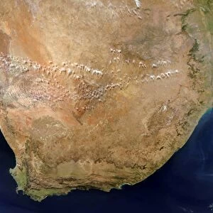
Fine Art Print : Asia. Satellite image centred on Asia. The North Pole is at upper right


![]()
Fine Art Prints from Science Photo Library
Asia. Satellite image centred on Asia. The North Pole is at upper right
Asia. Satellite image centred on Asia. The North Pole is at upper right. Water is blue, vegetation is green, arid areas are brown, and snow and ice are white. The terrain of Asia varies from deserts (brown, central and southern Asia), to tropical rainforests (dark green, South-East Asia and the Malay Archipelago), to grasslands, forests and tundra (lighter green, northern Asia), and mountain ranges (centre). Also seen is Europe (upper left), Greenland (white, top centre), part of North America (top right), part of the Pacific Ocean (right), Australia (bottom right), and the Indian Ocean and the island of Madagascar (lower left). For this area at night, see E074/054
Science Photo Library features Science and Medical images including photos and illustrations
Media ID 6351439
© PLANETOBSERVER/SCIENCE PHOTO LIBRARY
Alaska Arctic Australia Canada China Continent Continental Deserts Earth Observation Eurasia Eurasian Forests From Space Greenland Himalayas India Indian Japan Land Malay Archipelago Middle East Mountains Pacific Russia Satellite Satellite Image
20"x16" (+3" Border) Fine Art Print
Discover the breathtaking beauty of Asia through the lens of Science Photo Library's finest. Our Media Storehouse range of Fine Art Prints presents this stunning satellite image of Asia, where the vibrant blues of the surrounding waters contrast against the lush greens of vegetation, the arid browns of deserts, and the pristine whites of snow-capped mountains. Transport yourself to this captivating part of the world with this visually striking and high-quality print.
20x16 image printed on 26x22 Fine Art Rag Paper with 3" (76mm) white border. Our Fine Art Prints are printed on 300gsm 100% acid free, PH neutral paper with archival properties. This printing method is used by museums and art collections to exhibit photographs and art reproductions.
Our fine art prints are high-quality prints made using a paper called Photo Rag. This 100% cotton rag fibre paper is known for its exceptional image sharpness, rich colors, and high level of detail, making it a popular choice for professional photographers and artists. Photo rag paper is our clear recommendation for a fine art paper print. If you can afford to spend more on a higher quality paper, then Photo Rag is our clear recommendation for a fine art paper print.
Estimated Image Size (if not cropped) is 35.9cm x 50.8cm (14.1" x 20")
Estimated Product Size is 55.9cm x 66cm (22" x 26")
These are individually made so all sizes are approximate
Artwork printed orientated as per the preview above, with portrait (vertical) orientation to match the source image.
FEATURES IN THESE COLLECTIONS
> Africa
> Madagascar
> Maps
> Africa
> Madagascar
> Related Images
> Animals
> Mammals
> Cats (Domestic)
> Russian Blue
> Animals
> Mammals
> Cats (Domestic)
> Russian White
> Animals
> Mammals
> Muridae
> Water Mouse
> Arts
> Artists
> O
> Oceanic Oceanic
> Arts
> Landscape paintings
> Forest and woodland scenes
> Forest artwork
EDITORS COMMENTS
This print showcases the vast and diverse continent of Asia, as seen from space. The satellite image captures the immense beauty and geographical features that define this landmass. From the North Pole at the upper right corner to the arid brown deserts of central and southern Asia, every element is vividly portrayed. The vibrant blue waters surrounding Asia contrast with the lush green vegetation found in Southeast Asia and the Malay Archipelago's tropical rainforests. Moving towards northern Asia, lighter shades of green depict grasslands, forests, tundra, and majestic mountain ranges at its center. In addition to highlighting Asia's stunning landscapes, this photo also offers a glimpse of neighboring continents and regions. Europe appears in the upper left corner while Greenland dominates the top center with its pristine white expanse. Part of North America can be observed on the top right side alongside a portion of the Pacific Ocean. Australia graces us with its presence in bottom right while lower left reveals glimpses of Indian Ocean along with Madagascar island. This remarkable satellite image not only provides an awe-inspiring view but also serves as a testament to Earth's natural wonders. It reminds us how interconnected our planet truly is, showcasing both human-inhabited areas like China, Russia, Japan, India as well as uninhabited terrains like Alaska or remote oceanic expanses such as Indian Ocean.
MADE IN AUSTRALIA
Safe Shipping with 30 Day Money Back Guarantee
FREE PERSONALISATION*
We are proud to offer a range of customisation features including Personalised Captions, Color Filters and Picture Zoom Tools
SECURE PAYMENTS
We happily accept a wide range of payment options so you can pay for the things you need in the way that is most convenient for you
* Options may vary by product and licensing agreement. Zoomed Pictures can be adjusted in the Cart.